Positioned in the northernmost part of the province, the town is commonly referred to as the “Gateway to Agusan del Sur” and “The Last Frontier of Agusan del Sur”. The town plays a significant role in the agricultural sector of the province, as it is a major producer of crops such as coconut, banana, vegetables, and notably, abaca.
The municipality covers 950.50 square kilometers or 366.99 square miles, accounting for 9.51% of the total area of Agusan del Sur. According to the 2020 Census, its population was 35,196, which makes up 4.76% of Agusan del Sur’s total population and 1.25% of the Caraga region’s overall population. With these statistics, the population density is calculated at 37 people per square kilometer or 96 people per square mile.
Sibagat has 24 barangays. The graph and table below show the population per barangay for the years 2015 and 2020.
Barangay
Population (2020)
Population (2015)
Anislagan
1,704
1,998
Balit
1,062
868
Baylo
1,448
1,555
Binicalan
2,892
3,353
Cecilia
1,195
1,135
Coalicion
2,678
1,398
Culi
1,142
1,008
Dimasalang
1,768
1,387
Don Alejandro
2,546
2,600
Don Pedro
234
241
Doña Flavia
2,827
2,614
Doña Maxima
1,406
1,467
Mahagsay
1,016
1,009
Mahapag
749
730
Mahayahay
1,332
795
Muritula
905
743
Nuevo Trabajo
2,256
1,876
Poblacion
1,755
1,815
Policarpo
612
486
San Isidro
898
807
San Pedro
1,131
1,219
Santa Ines
2,114
1,748
Santa Rita
349
301
Santiago
568
499
Wegguam
609
457
San Luis Total
35,196
32,109
Economy
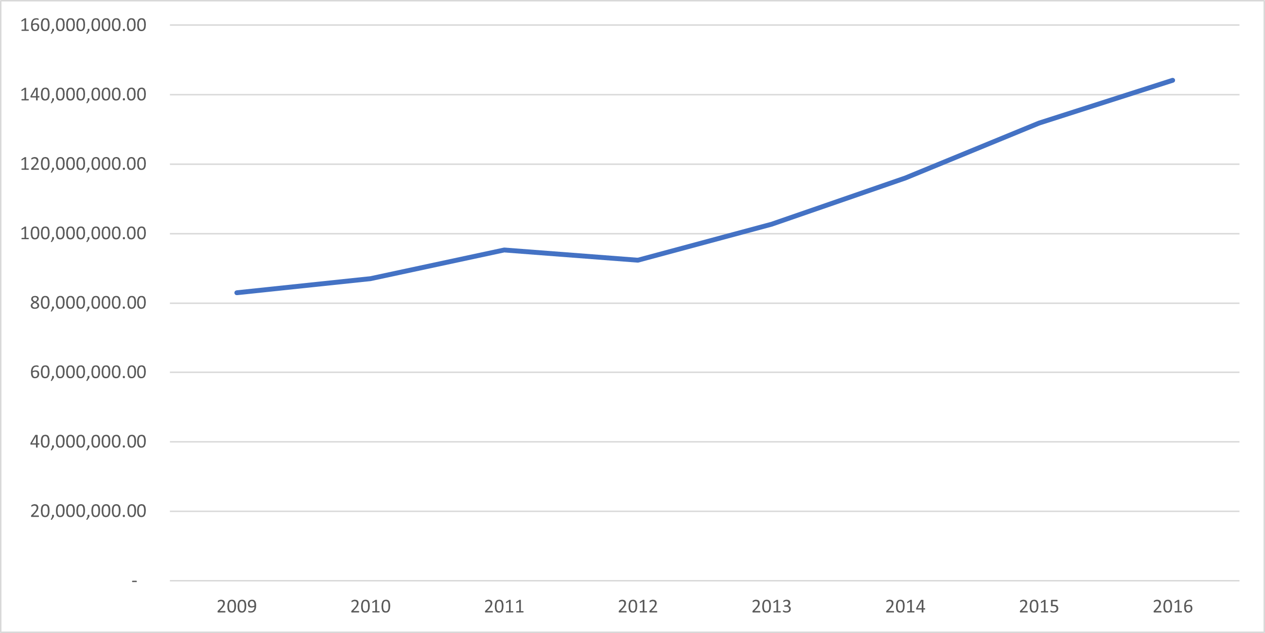
Fiscal Year
Annual Regular Income
2009
82,992,839.61
2010
87,011,731.29
2011
95,321,528.30
2012
92,300,332.73
2013
102,700,516.50
2014
116,045,945.22
2015
131,797,562.84
2016
144,192,320.57
End notes:
Annual Regular Income = Locally Sourced Revenue + Internal Revenue Allotment (IRA) Current Year + Other Shares from National Tax Collection
Locally Sourced Revenue = Real Property Tax (General Fund) + Tax on Business + Other Taxes + Regulatory Fees + Service/User Charges + Receipts from Economic Enterprises
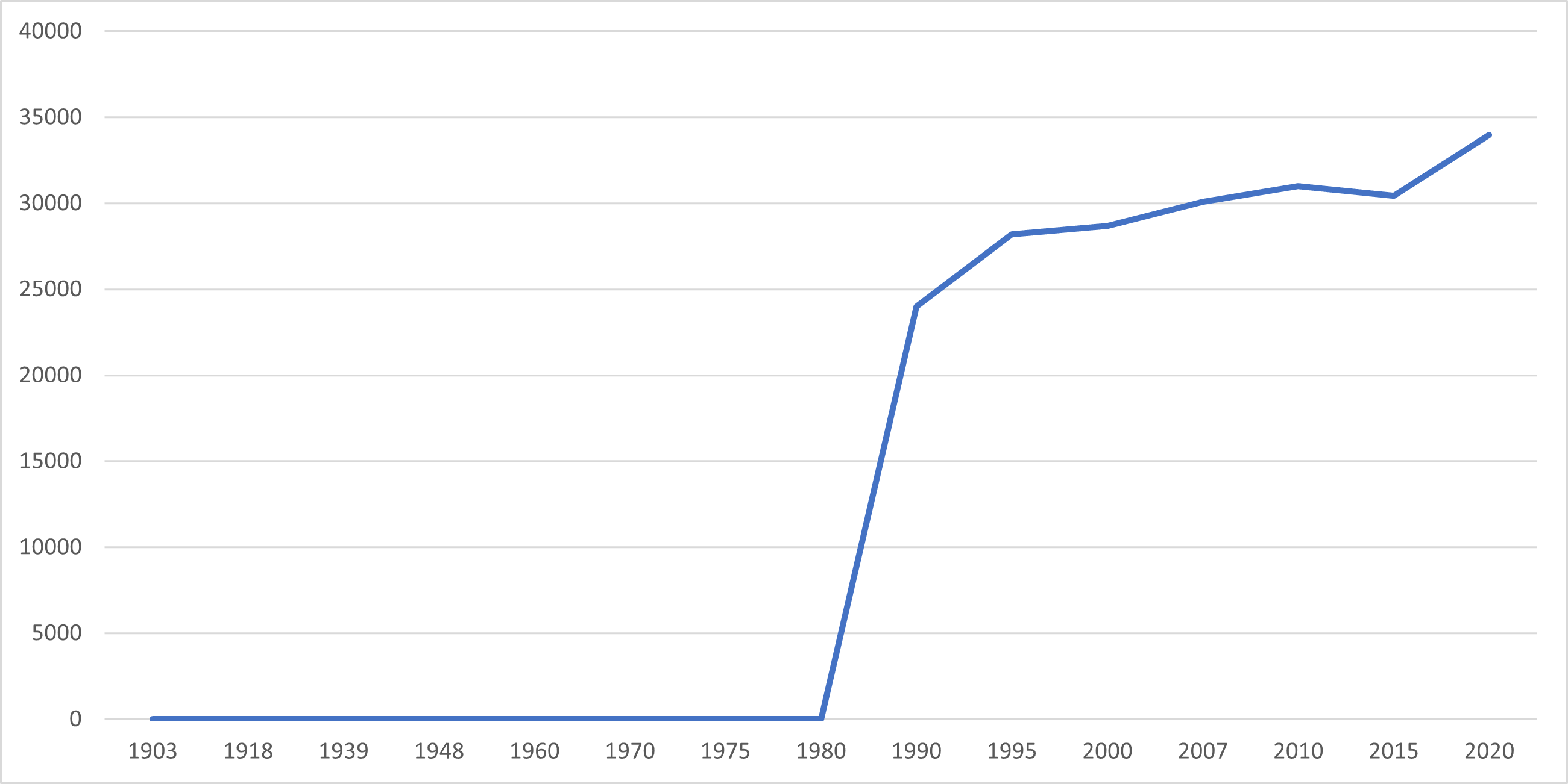
Population
Census date
Population
1903
–
1918
–
1939
–
1948
–
1960
–
1970
–
1975
–
1980
–
1990
24,004
1995
28,185
2000
28,685
2007
30,074
2010
30,985
2015
30,442
2020
33,957
Between 1990 and 2020, the population of Sibagat rose from 24,004 to 33,957, indicating an increase of 9,953 individuals over the span of 30 years. As per the latest census conducted in 2020, the population of Sibagat has experienced a positive growth rate of 2.33%, resulting in an additional 3,515 individuals as compared to the previous population of 30,442 in 2015.
Location
Distances
Sibagat is closest to the cities of Bayugan, Agusan del Sur, Butuan, Cabadbaran, Agusan del Norte, Tandag, Surigao del Sur, Gingoog, Misamis Oriental, and Bislig, Surigao del Sur, based on their great-circle distance from Sibagat. The nearest municipalities are Las Nieves, Agusan del Norte, Esperanza, Agusan del Sur, Remedios T. Romualdez, Agusan del Norte, Magallanes, Agusan del Norte, Prosperidad, Agusan del Sur, and Buenavista, Agusan del Norte. Sibagat is situated 819.18 kilometers (509.02 miles) away from the national capital.
Great-circle distance
Nearest towns
Las Nieves, Agusan del Norte, 14.01 kilometers (8.71 miles) to the Southwest (S47°W)