On June 15, 1968, San Luis was established as a municipality by separating the barrios of San Luis, Santa Inez, Nuevo Trabajo, Cualision, and Baylo from Esperanza and forming a new town under Republic Act 5262. Since the 1970s, the local economy of San Luis has predominantly relied on logging industries.
The land area of the municipality measures 950.50 square kilometers or 366.99 square miles, accounting for 9.51% of Agusan del Sur’s total area. According to the 2020 Census, the population of the municipality was 35,196, which comprises 4.76% of the entire population of Agusan del Sur province or 1.25% of the total population of the Caraga region. Based on these statistics, the population density can be calculated as 37 individuals per square kilometer or 96 individuals per square mile.
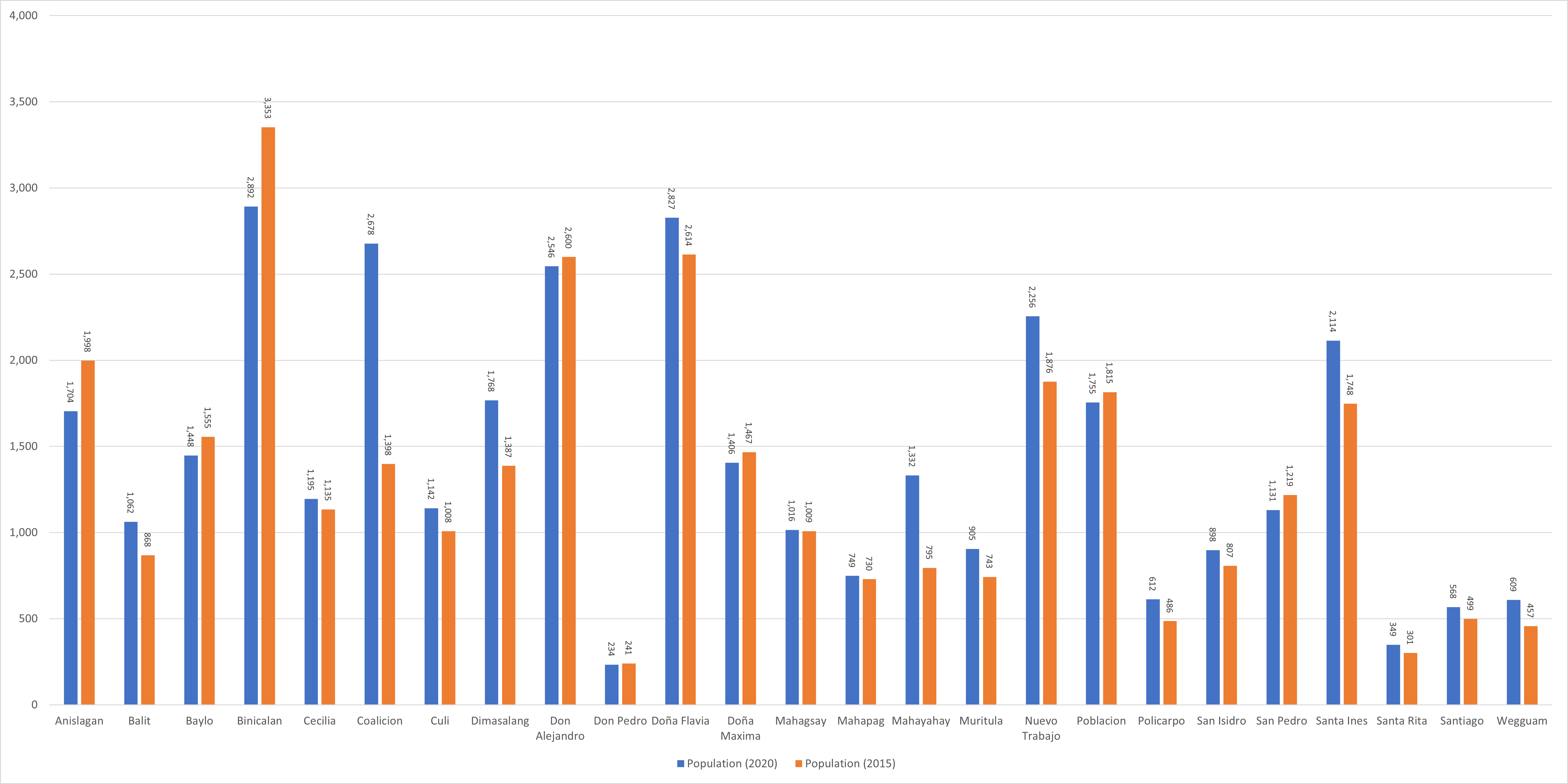
San Luis has 25 barangays. The graph and table below show the population per barangay for the years 2015 and 2020.
Barangay
Population (2020)
Population (2015)
Anislagan
1,704
1,998
Balit
1,062
868
Baylo
1,448
1,555
Binicalan
2,892
3,353
Cecilia
1,195
1,135
Coalicion
2,678
1,398
Culi
1,142
1,008
Dimasalang
1,768
1,387
Don Alejandro
2,546
2,600
Don Pedro
234
241
Doña Flavia
2,827
2,614
Doña Maxima
1,406
1,467
Mahagsay
1,016
1,009
Mahapag
749
730
Mahayahay
1,332
795
Muritula
905
743
Nuevo Trabajo
2,256
1,876
Poblacion
1,755
1,815
Policarpo
612
486
San Isidro
898
807
San Pedro
1,131
1,219
Santa Ines
2,114
1,748
Santa Rita
349
301
Santiago
568
499
Wegguam
609
457
San Luis Total
35,196
32,109
Economy
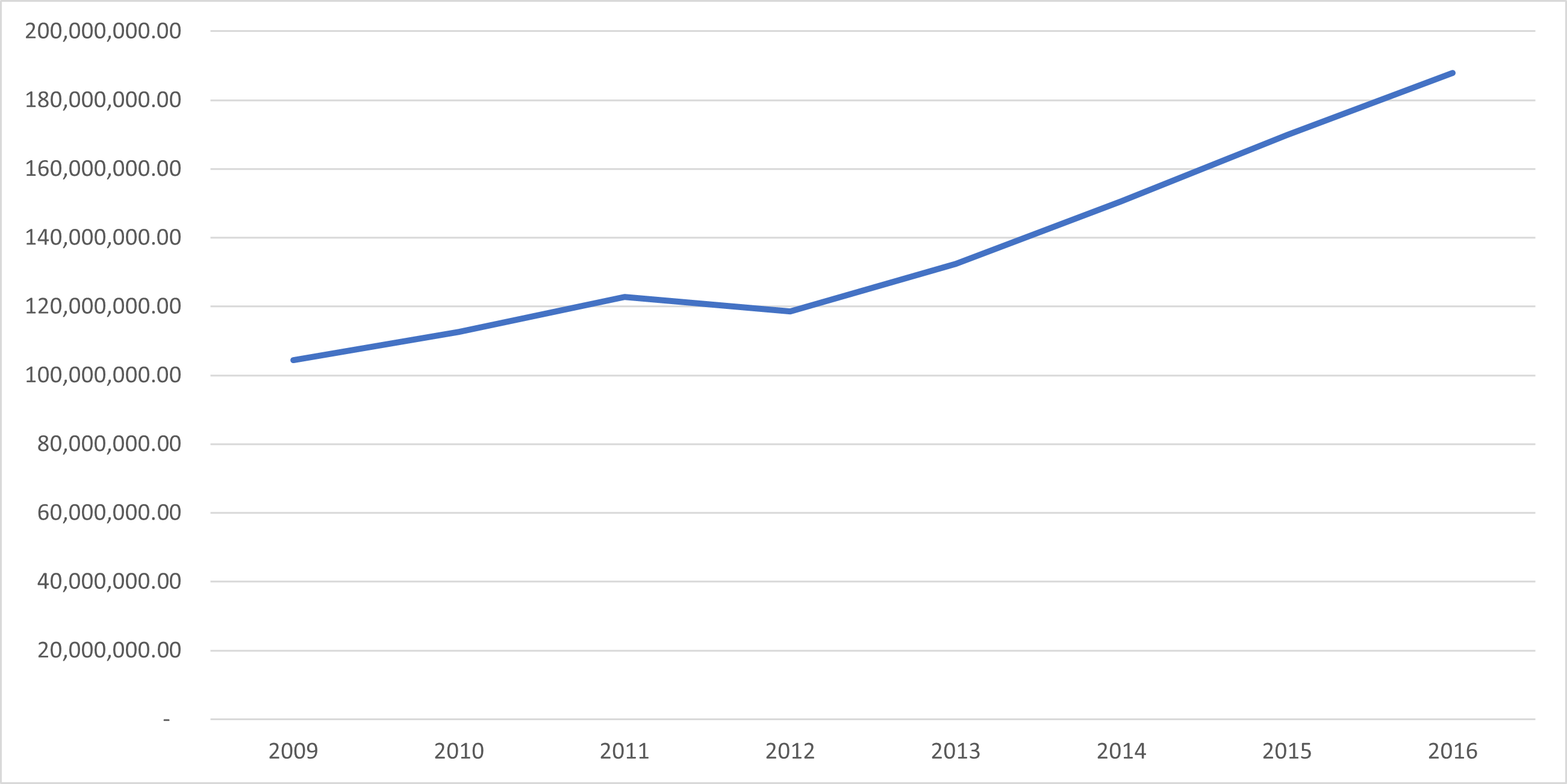
Fiscal Year
Annual Regular Income
2009
104,419,275.81
2010
112,575,965.28
2011
122,706,585.88
2012
118,530,455.45
2013
132,423,907.62
2014
150,657,950.39
2015
169,932,341.84
2016
187,910,383.93
End notes:
Annual Regular Income = Locally Sourced Revenue + Internal Revenue Allotment (IRA) Current Year + Other Shares from National Tax Collection
Locally Sourced Revenue = Real Property Tax (General Fund) + Tax on Business + Other Taxes + Regulatory Fees + Service/User Charges + Receipts from Economic Enterprises
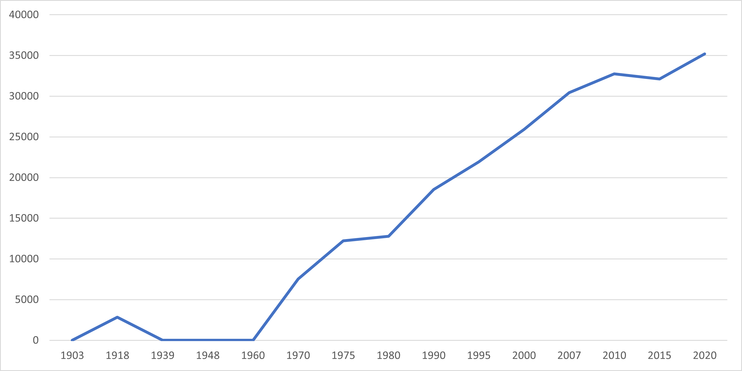
Population
Census date
Population
1903
–
1918
2,850
1939
–
1948
–
1960
–
1970
7,531
1975
12,226
1980
12,793
1990
18,521
1995
21,910
2000
25,901
2007
30,424
2010
32,733
2015
32,109
2020
35,196
Over the span of 102 years, the population of San Luis experienced a remarkable growth, rising from 2,850 residents in 1918 to 35,196 inhabitants in 2020, which translates into an increase of 32,346 individuals. The most recent census conducted in 2020 revealed a positive growth rate of 1.95%, equivalent to an uptick of 3,087 people when compared to the previous population of 32,109 recorded in 2015.
Location
Distances
Based on the great-circle distance (the shortest distance between two points over the surface of the Earth), the cities closest to San Luis areBayugan, Agusan del Sur, Butuan, Bislig, Surigao del Sur, Cabadbaran, Agusan del Norte, Malaybalay, Bukidnon, and Gingoog, Misamis Oriental. The nearest municipalities areTalacogon, Agusan del Sur, Esperanza Agusan del Sur, ProsperidadAgusan del Sur, La PazAgusan del Sur, San Francisco,Agusan del Sur, and Las Nieves, Agusan del Norte. Its distance from the national capital is 850.52 kilometers (528.49 miles). The following list delineates such distance measurements