GOV.PH

Republic of The Philippines

Province of Agusan del Sur

Esperanza, the oldest town in northern Agusan del Sur, used to be the largest municipality in the province in terms of the land area until the late 20th century. However, several municipalities were established out of its territories, namely Las Nieves, San Luis, Sibagat, and Bayugan, which eventually became a city and have since surpassed Esperanza in terms of economy and population.

The land area of the municipality covers 1,355.48 square kilometers or 523.35 square miles, which makes up 13.57% of Agusan del Sur’s entire area. According to the 2020 Census, the population of the municipality was 59,353, comprising 8.03% of the total population of Agusan del Sur province, and 2.12% of the overall population of the Caraga region. With these statistics, the population density is estimated to be 44 inhabitants per square kilometer or 113 inhabitants per square mile.


47

Barangay count


8513

Postal code


1,355.48 km²

Land Area


59,353

Population (2020)


44 / km²

Density

Coordinates


17.1 meters

Estimated elevation above sea level

Barangays

Esperanza has 47 barangays. The graph and table below show the population per barangay for the years 2015 and 2020.

BarangayPopulation (2020)Population (2015)
Agsabu931812
Aguinaldo729540
Anolingan1,4491,649
Bakingking424496
Balubo913816
Bentahon1,0781,084
Bunaguit1,8391,192
Catmonon1,9381,733
Cebulan690432
Concordia811935
Crossing Luna1,4411,381
Cubo817877
Dakutan3,4533,391
Duangan1,6581,610
Guadalupe4,1114,046
Guibonon329502
Hawilian2,7472,358
Kalabuan326283
Kinamaybay885683
Labao980930
Langag1,1251,197
Maasin1,0991,091
Mac-Arthur222200
Mahagcot951841
Maliwanag262296
Milagros1,5081,172
Nato2,0391,732
New Gingoog503495
Odiong598622
Oro2,1831,922
Piglawigan2,0551,882
Poblacion5,2194,778
Remedios1,6111,447
Salug1,4331,238
San Isidro396385
San Jose197150
San Toribio2,1032,424
San Vicente388765
Santa Fe2,2541,990
Segunda342293
Sinakungan443464
Tagabase883827
Taganahaw402382
Tagbalili1,051546
Tahina1,226769
Tandang Sora854768
Valentina457375


Economy

Fiscal Year Annual Regular Income 
2009 167,227,368.66
2010 179,714,722.59
2011 194,675,404.82
2012 192,976,051.01
2013 190,277,807.36
2014 220,839,585.43
2015 252,756,116.40
2016 279,583,540.42


End notes:

  • Annual Regular Income = Locally Sourced Revenue + Internal Revenue Allotment (IRA) Current Year + Other Shares from National Tax Collection
  • Locally Sourced Revenue = Real Property Tax (General Fund) + Tax on Business + Other Taxes + Regulatory Fees + Service/User Charges + Receipts from Economic Enterprises

Population

Census datePopulation
1903
1918
1939
1948
1960
197037,816
197543,603
198056,367
199078,725
199589,999
200093,623
200795,032
201099,361
2015103,202
2020109,499

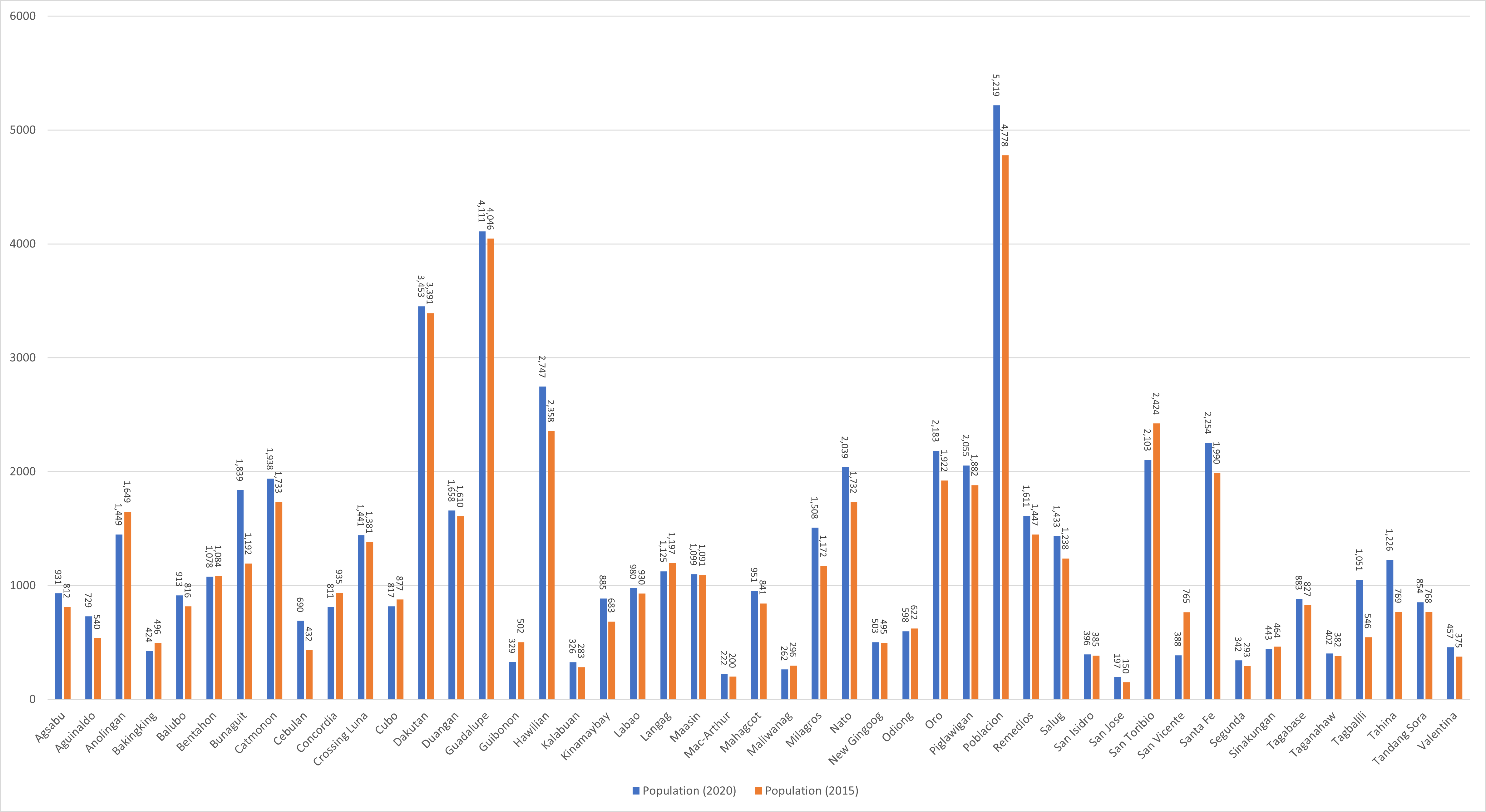
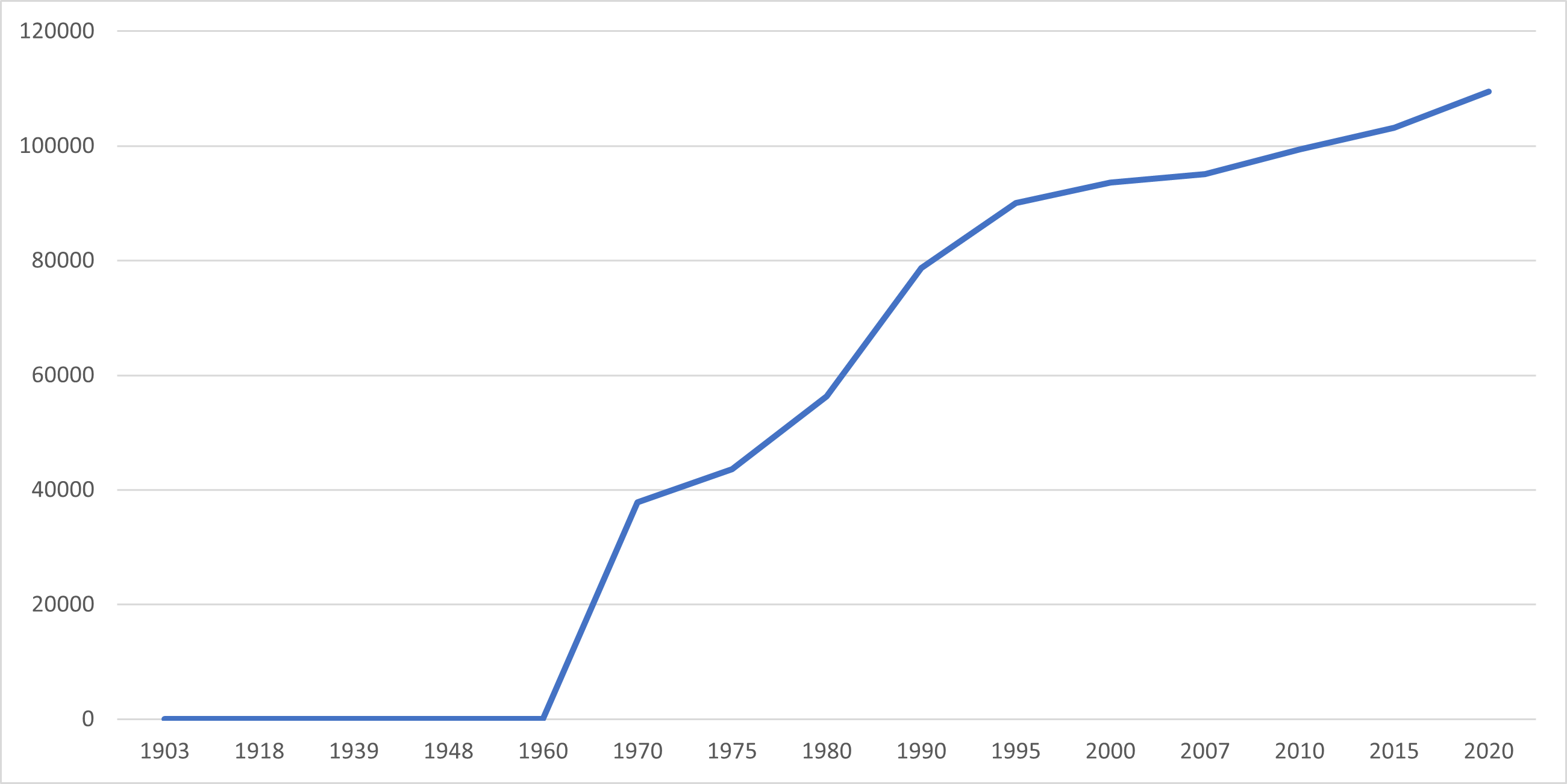
Esperanza’s population increased by 56,459 people over 102 years, rising from 2,894 individuals in 1918 to 59,353 in 2020. According to the latest census figures in 2020, there was a positive growth rate of 1.69%, resulting in an increase of 4,552 individuals from the previous population of 54,801 in 2015.

Location

Distances


Based on the great-circle distance (the shortest distance between two points over the surface of the Earth), the cities closest to Esperanza are Bayugan, Agusan del Sur, Butuan, Cabadbaran, Agusan del Norte, Gingoog, Misamis Oriental, Tandag, Surigao del Sur, and Malaybalay, Bukidnon. The nearest municipalities are Las Nieves, Agusan del Norte, Sibagat, Agusan del Sur, San Luis, Agusan del Sur, Talacogon, Agusan del Sur, Prosperidad, Agusan del Sur, and Magallanes, Agusan del Norte. Its distance from the national capital is 828.64 kilometers (514.90 miles). The following list delineates such distance measurements.

Great-circle distance


Nearest towns

  • Las Nieves, Agusan del Norte, 8.16 kilometers (5.07 miles) to the Northwest (N37°W)
  • Sibagat, Agusan del Sur, 16.99 kilometers (10.56 miles) to the North‑Northeast (N18°E)
  • San Luis, Agusan del Sur, 22.25 kilometers (13.82 miles) to the South‑Southeast (S27°E)
  • Talacogon, Agusan del Sur, 29.56 kilometers (18.37 miles) to the South‑Southeast (S32°E)
  • Prosperidad, Agusan del Sur, 30.71 kilometers (19.08 miles) to the East‑Southeast (S75°E)
  • Magallanes, Agusan del Norte, 40.56 kilometers (25.20 miles) to the North‑Northwest (N20°W)

Nearest cities

  • Bayugan, Agusan del Sur, 12.07 kilometers (7.50 miles) to the East‑Northeast (N69°E)
  • Butuan, 33.25 kilometers (20.66 miles) to the North‑Northwest (N23°W)
  • Cabadbaran, Agusan del Norte, 50.90 kilometers (31.63 miles) to the North‑Northwest (N14°W)
  • Gingoog, Misamis Oriental, 61.85 kilometers (38.43 miles) to the West‑Northwest (N74°W)
  • Tandag, Surigao del Sur, 75.39 kilometers (46.85 miles) to the Northeast (N53°E
  • Malaybalay, Bukidnon, 80.83 kilometers (50.22 miles) to the Southwest (S44°W)

For more information about the Province of Agusan del Sur