Bayugan, the only city in Agusan del Sur, obtained its cityhood status through the enactment of Republic Act No. 9405. Positioned in the northern region of Agusan del Sur, Bayugan is renowned as the “cut-flower capital” of the province, owing to its thriving cut-flower industry. The local climate in the highland barangays is well-suited for producing high-yield cut-flowers. In addition, the city is a significant contributor to the province’s agricultural sector, being one of the primary producers of rice and vegetables, and even supplying neighboring municipalities and provinces.
The urban center occupies 688.77 square kilometers or 265.94 square miles, making up 6.89% of the total area of Agusan del Sur. As per the 2020 Census, the city’s population was 109,499, which represents 14.81% of the entire population of Agusan del Sur and 3.90% of the Caraga region’s overall population. Given these figures, the population density is calculated to be 159 individuals per square kilometer or 412 individuals per square mile.
Bayugan has 43 barangays. The graph and table below show the population per barangay for the years 2015 and 2020.
Barangay
Population (2020)
Population (2015)
Berseba
1,808
1,585
Bucac
4,726
3,918
Cagbas
2,601
1,923
Calaitan
1,971
1,913
Canayugan
1,448
1,156
Charito
1,384
1,549
Claro Cortez
1,067
819
Fili
3,662
2,949
Gamao
1,172
1,096
Getsemane
446
398
Grace Estate
632
677
Hamogaway
1,635
1,508
Katipunan
1,145
1,225
Mabuhay
1,999
1,730
Magkiangkang
1,723
1,801
Mahayag
757
629
Marcelina
3,900
3,789
Maygatasan
4,908
4,818
Montivesta
786
709
Mt. Ararat
348
684
Mt. Carmel
2,375
2,387
Mt. Olive
1,593
1,509
New Salem
715
569
Noli
4,836
3,712
Osmeña
1,654
1,589
Panaytay
624
695
Pinagalaan
1,410
1,411
Poblacion
16,853
16,010
Sagmone
1,100
1,301
Saguma
2,237
2,215
Salvacion
5,568
5,886
San Agustin
697
679
San Isidro
1,094
1,206
San Juan
4,054
3,307
Santa Irene
4,570
3,651
Santa Teresita
1,967
1,828
Santo Niño
1,551
1,606
Taglatawan
12,632
12,838
Taglibas
499
402
Tagubay
891
930
Verdu
1,502
1,424
Villa Undayon
1,444
1,609
Wawa
1,515
1,562
Economy
Fiscal Year
Annual Regular Income
2009
278,073,004.71
2010
166,756,344.40
2011
189,342,688.31
2012
519,253,055.70
2013
557,439,566.52
2014
627,914,557.98
2015
716,545,014.63
2016
792,940,543.26
End notes:
Annual Regular Income = Locally Sourced Revenue + Internal Revenue Allotment (IRA) Current Year + Other Shares from National Tax Collection
Locally Sourced Revenue = Real Property Tax (General Fund) + Tax on Business + Other Taxes + Regulatory Fees + Service/User Charges + Receipts from Economic Enterprises
Population
Census date
Population
1903
–
1918
2,894
1939
9,247
1948
8,488
1960
31,825
1970
21,051
1975
23,377
1980
25,257
1990
36,139
1995
42,118
2000
44,151
2007
47,659
2010
51,897
2015
54,801
2020
59,353
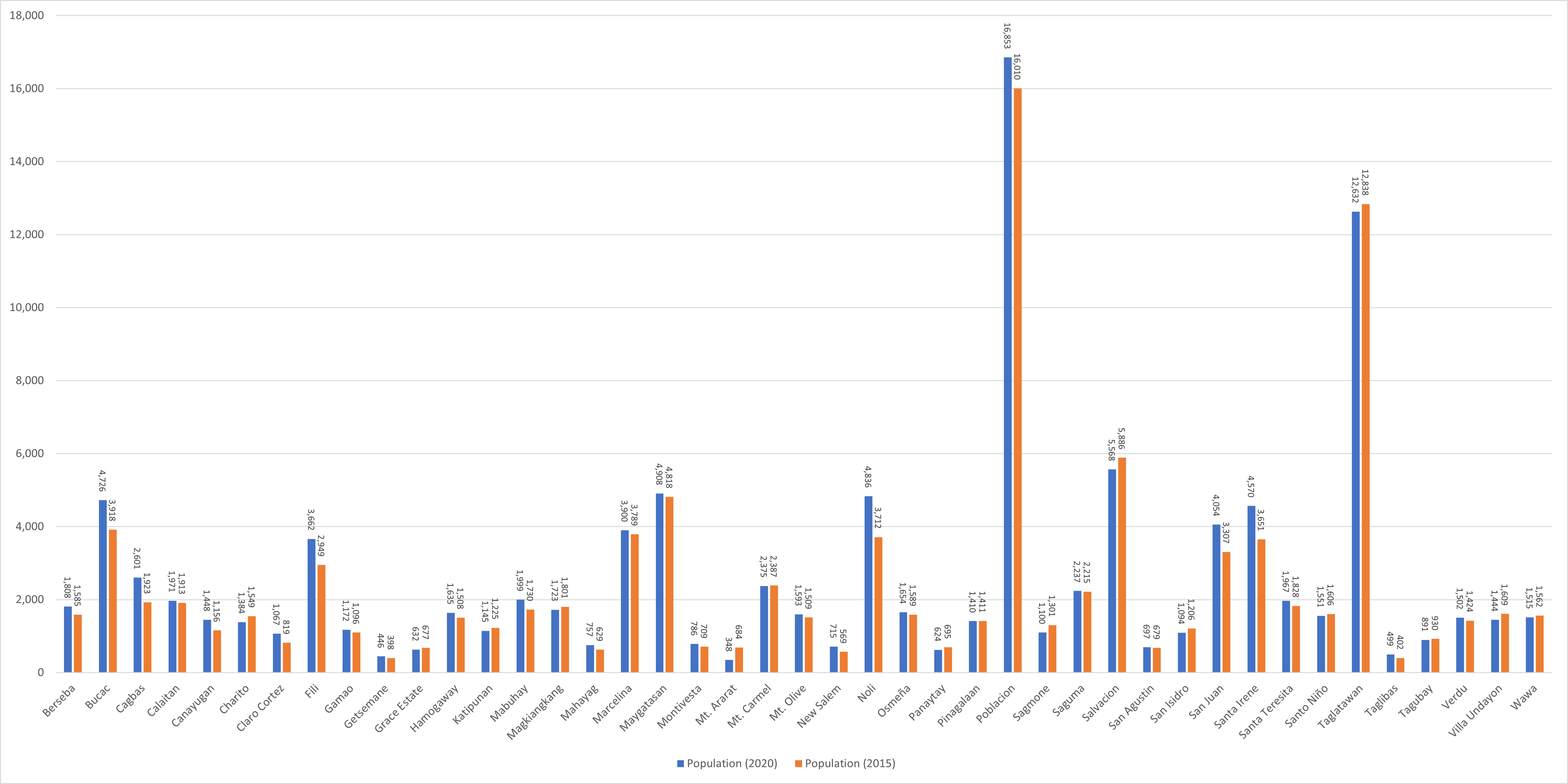
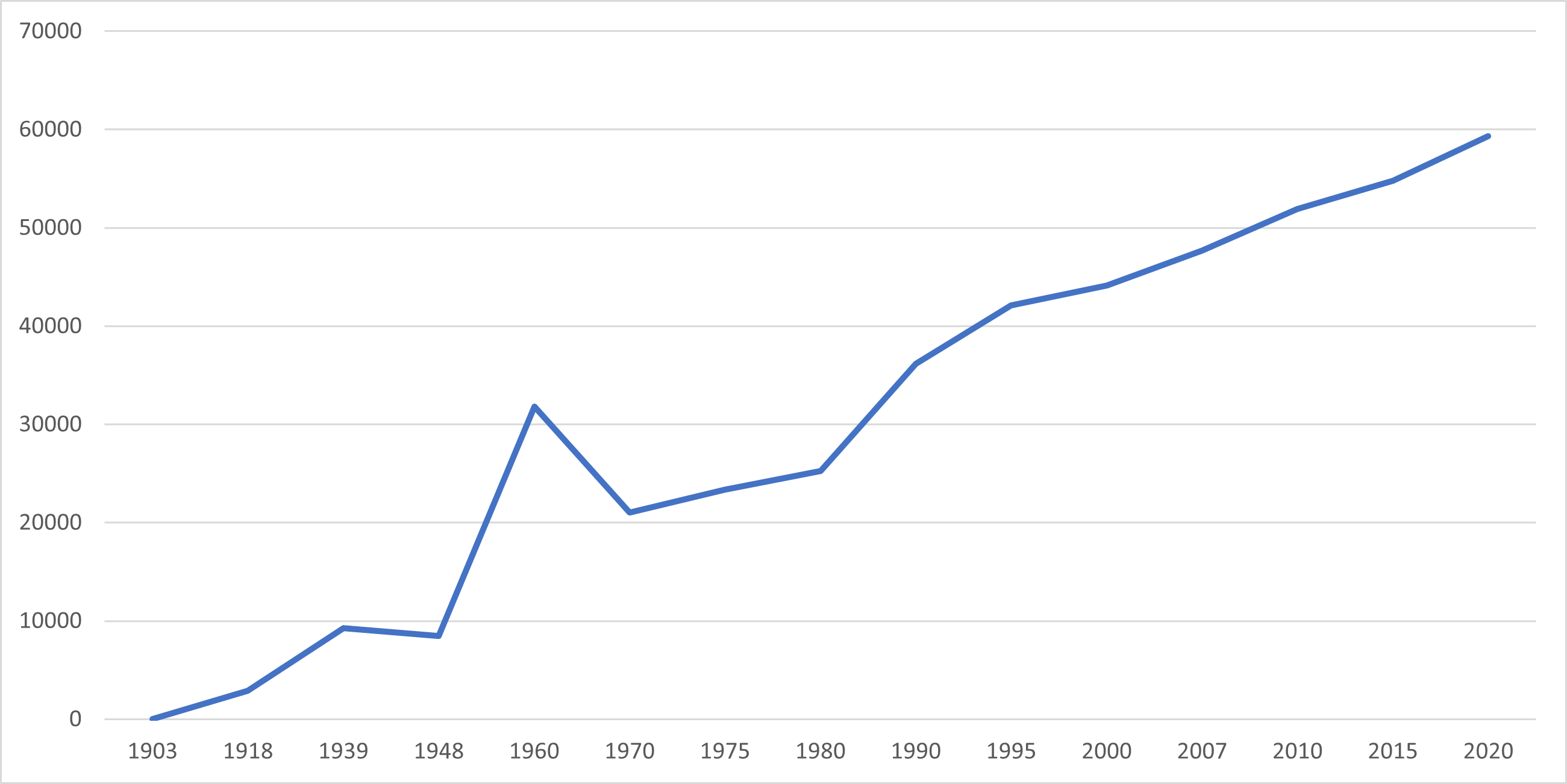
Over the span of 50 years, the population of Bayugan increased by 71,683 people, rising from 37,816 individuals in 1970 to 109,499 in 2020. The most recent census conducted in 2020 showed a 1.25% positive growth rate, representing a rise of 6,297 individuals from the previous population count of 103,202 in 2015.
Location
Distances
Based on the great-circle distance (the shortest distance between two points over the surface of the Earth), the cities closest to Bayugan are Butuan, Cabadbaran, Agusan del Norte, Tandag, Surigao del Sur, Gingoog, Misamis Oriental, Bislig, Surigao del Sur, and Malaybalay, Bukidnon. The nearest municipalities are Esperanza, Agusan del Sur, Sibagat, Agusan del Sur, Las Nieves, Agusan del Norte, Prosperidad, Agusan del Sur, San Luis, Agusan del Sur, and Talacogon, Agusan del Sur. Its distance from the national capital is 832.23 kilometers (517.12 miles). The following list delineates such distance measurements.