GOV.PH

Republic of The Philippines

Province of Agusan del Sur

Talacogon was named after the cogon grass that thrived in the area, and it was the indigenous people who resided in the region before the Spanish arrived in the Agusan River basin in the 18th century who gave it this name.

According to the 2020 Census, the municipality has a land area of 405.25 square kilometers or 156.47 square miles, which comprises 4.06% of Agusan del Sur’s total area. The population of the municipality was recorded as 39,678, representing 5.37% of the total population of Agusan del Sur province, or 1.41% of the overall population of the Caraga region. Based on these figures, the population density of the municipality is computed to be 98 inhabitants per square kilometer or 254 inhabitants per square mile.


16

Barangay count


8510

Postal code


405.25 km²

Land Area


39,678

Population (2020)


98 / km²

Density

Coordinates


20.5 meters

Estimated elevation above sea level

Barangays

Talacogon has 16 barangays. The graph and table below show the population per barangay for the years 2015 and 2020.

BarangayPopulation (2020)Population (2015)
Batucan2,1602,181
BuenaGracia2,1871,846
Causwagan3,1323,055
Culi566511
Del Monte7,7777,750
Desamparados1,8641,361
La Flora1,3971,212
Labnig3,4262,888
Maharlika961855
Marbon1,8441,570
Sabang Gibung833961
San Agustin4,0124,314
San Isidro987897
San Nicolas2,3602,307
Zamora1,3161,411
Zillovia4,8565,255


Economy

Fiscal YearAnnual Regular Income 
200978,239,874.16
201089,430,455.34
201194,103,723.88
201292,663,011.01
2013103,816,160.31
2014114,753,140.36
2015129,544,128.93
2016145,433,666.50


End notes:

  • Annual Regular Income = Locally Sourced Revenue + Internal Revenue Allotment (IRA) Current Year + Other Shares from National Tax Collection
  • Locally Sourced Revenue = Real Property Tax (General Fund) + Tax on Business + Other Taxes + Regulatory Fees + Service/User Charges + Receipts from Economic Enterprises

Population

Census datePopulation
19032,811
19182,201
19393,242
19483,186
19604,861
19707,719
19759,110
198011,452
199021,655
199527,517
200030,879
200733,093
201037,224
201538,374
202039,678


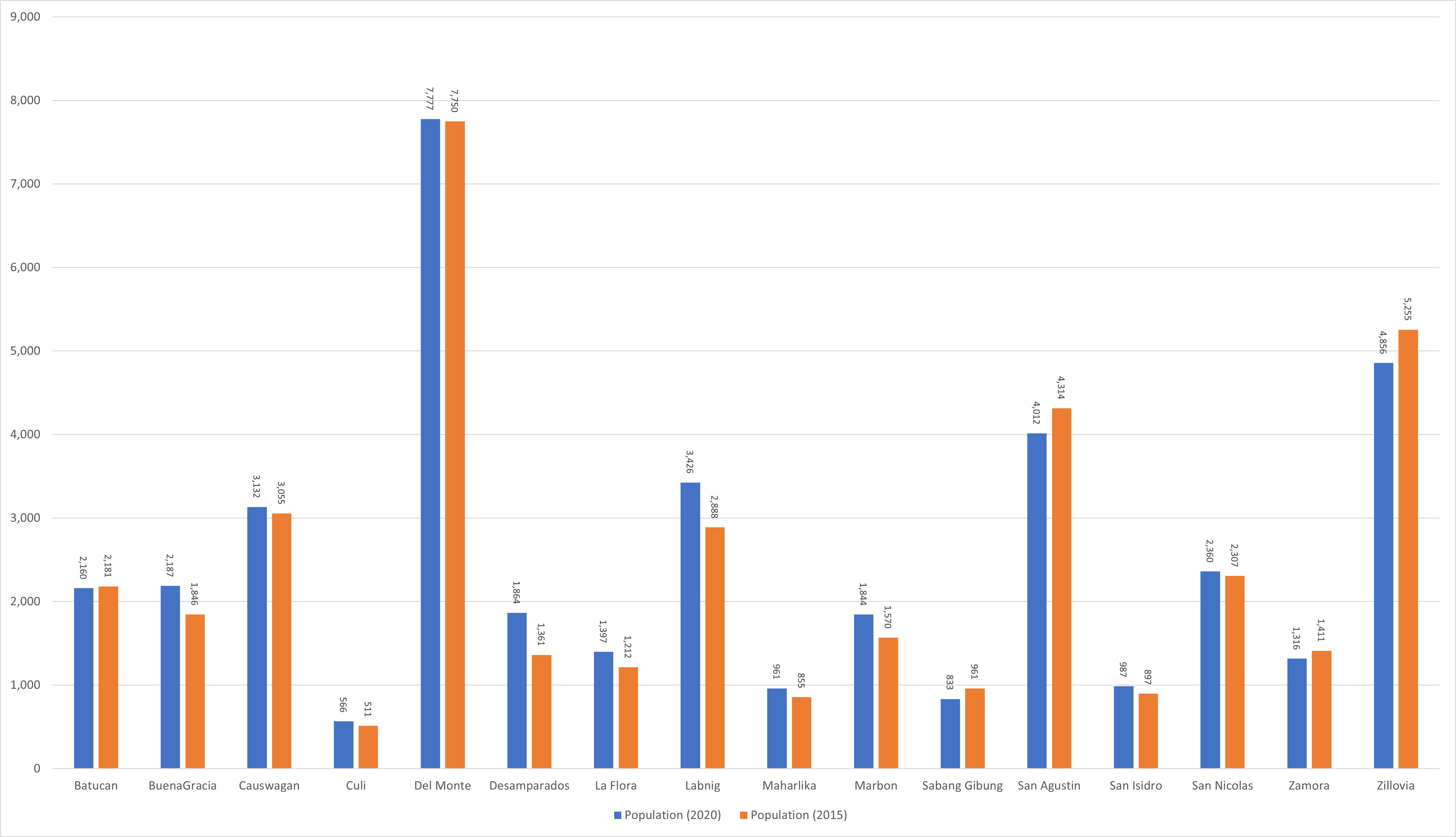
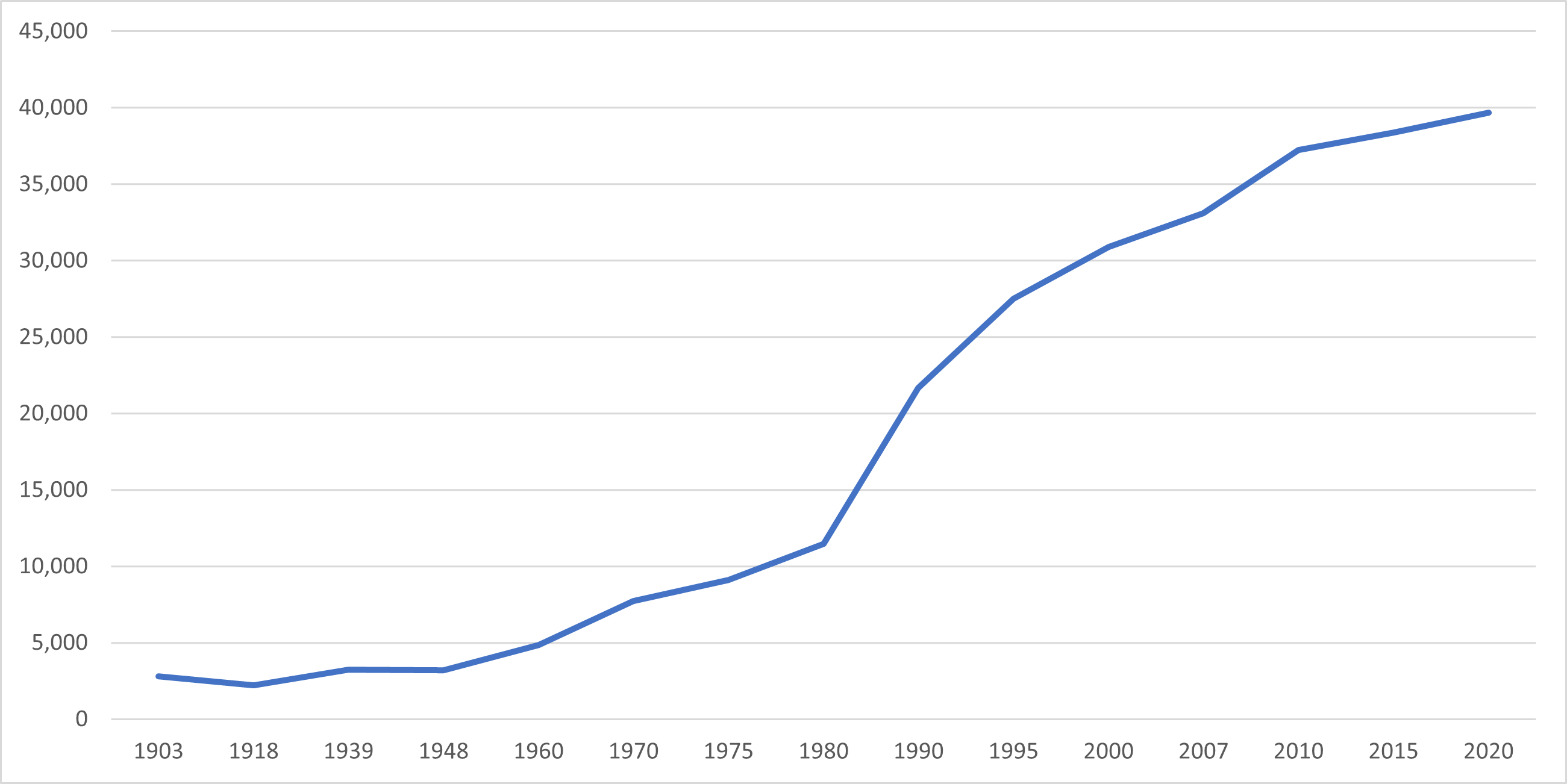
Between 1903 and 2020, the population of Talacogon grew from 2,811 to 39,678, indicating an increase of 36,867 individuals over a period of 117 years. As per the latest census conducted in 2020, the population of Talacogon has experienced a positive growth rate of 0.71%, resulting in an additional 1,304 individuals as compared to the previous population of 38,374 in 2015.

Location

Distances


The cities closest to Talacogon, based on the great-circle distance, are Bayugan, Agusan del Sur, Butuan, Agusan del Norte, Bislig, Surigao del Sur, Malaybalay, Bukidnon, Cabadbaran, Agusan del Norte, and Tandag, Surigao del Sur. The nearest municipalities are San Luis, La Paz, San Francisco, Prosperidad, Rosario, and Esperanza, all of which are in Agusan del Sur. The great-circle distance between Talacogon and the national capital is 858.07 kilometers (533.18 miles).

Great-circle distance


Nearest towns

Nearest cities

  • Bayugan, Agusan del Sur, 29.67 kilometers (18.44 miles) to the North (N8°W)
  • Butuan, 62.62 kilometers (38.91 miles) to the North‑Northwest (N27°W)
  • Bislig, Surigao del Sur, 63.87 kilometers (39.69 miles) to the East‑Southeast (S66°E)
  • Malaybalay, Bukidnon, 79.27 kilometers (49.26 miles) to the West‑Southwest (S66°W)
  • Cabadbaran, Agusan del Norte, 79.55 kilometers (49.43 miles) to the North‑Northwest (N20°W)
  • Tandag, Surigao del Sur, 83.14 kilometers (51.66 miles) to the North‑Northeast (N33°E)

For more information about the Province of Agusan del Sur