GOV.PH

Republic of The Philippines

Province of Agusan del Sur

On June 18, 1960, Republic Act No. 2650 established Prosperidad as a municipality. The town of Prosperidad is renowned for hosting the Naliyagan Festival, an annual celebration that involves the whole province of Agusan del Sur. Additionally, it holds its own festival called the Angot Festival, celebrated every 28th of September, in honor of St. Michael the Archangel.

With a land area of 505.15 square kilometers or 195.04 square miles, the municipality comprises 5.06% of Agusan del Sur’s total area. Based on the 2020 Census, its population was 88,321, accounting for 11.95% of Agusan del Sur province’s total population, and 3.15% of the Caraga region’s overall population. These figures result in a population density of 175 inhabitants per square kilometer or 453 inhabitants per square mile.


32

Barangay count


8500

Postal code


505.15 km²

Land Area


88,321

Population (2020)


175 / km²

Density

Coordinates


42.9 meters

Estimated elevation above sea level

Barangays

Prosperidad has 32 barangays. The graph and table below show the population per barangay for the years 2015 and 2020.

BarangayPopulation (2020)Population (2015)
Aurora3,0673,251
Awa2,0911,888
Azpetia2,3261,850
La Caridad1,7331,769
La Perian965835
La Purisima2,8022,276
La Suerte1,8091,772
La Union1,8121,853
Las Navas1,7151,785
Libertad1,071985
Los Arcos2,8172,606
Lucena3,4913,511
Mabuhay2,4472,013
Magsaysay2,4662,339
Mapaga1,6151,558
Napo1,176953
New Maug1,6791,480
Patin-ay9,6958,505
Poblacion13,55912,731
Salimbogaon873790
Salvacion2,9172,659
San Joaquin1,7811,720
San Jose2,8702,579
San Lorenzo1,6141,310
San Martin2,3752,379
San Pedro738851
San Rafael2,0631,973
San Roque8451,093
San Salvador1,6421,567
San Vicente3,6873,728
Santa Irene6,6296,148
Santa Maria1,9511,874


Economy

Fiscal Year Annual Regular Income 
2009 126,342,552.54
2010 135,025,930.11
2011149,991,975.91
2012 144,546,183.13
2013159,801,011.58
2014179,339,461.13
2015205,375,321.27
2016224,696,449.45


End notes:

  • Annual Regular Income = Locally Sourced Revenue + Internal Revenue Allotment (IRA) Current Year + Other Shares from National Tax Collection
  • Locally Sourced Revenue = Real Property Tax (General Fund) + Tax on Business + Other Taxes + Regulatory Fees + Service/User Charges + Receipts from Economic Enterprises

Population

Census datePopulation
1903
19182,212
19394,180
19484,417
196012,438
197023,328
197526,557
198033,824
199051,189
199561,804
200070,815
200775,390
201076,628
201582,631
202088,321


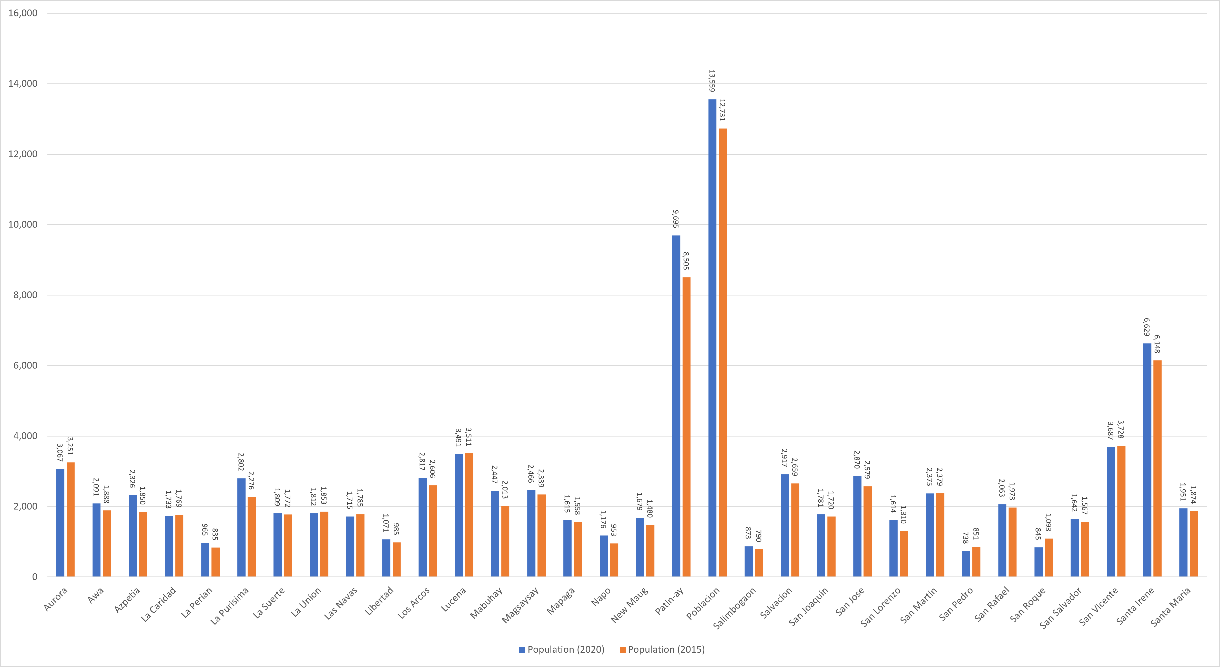
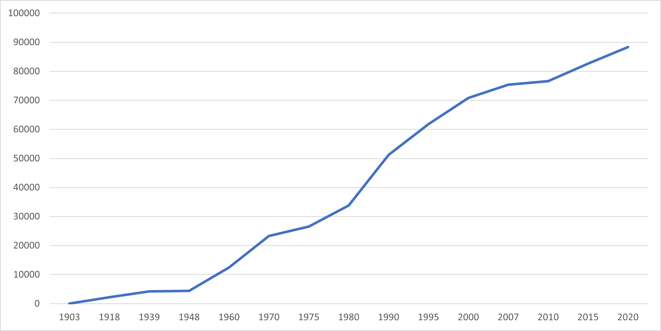
Over the span of 102 years, the population of Prosperidad increased by 86,109 people, rising from 2,212 individuals in 1918 to 88,321 in 2020. The most recent census conducted in 2020 showed a 1.41% positive growth rate, representing a rise of 5,690 individuals from the previous population count of 82,631 in 2015.

Location

Distances


Based on the shortest distance between two points over the surface of the Earth, the cities closest to Prosperidad are Bayugan, Agusan del Sur, Butuan, Tandag, Surigao del Sur, Bislig, Surigao del Sur, Cabadbaran, Agusan del Norte, and Gingoog, Misamis Oriental. Meanwhile, the nearest municipalities are San Francisco, Agusan del Sur, Lianga, Surigao del Sur, Talacogon, Agusan del Sur, San Luis, Agusan del Sur, Barobo, Surigao del Sur, and Rosario, Agusan del Sur. Prosperidad is situated at a distance of 853.07 kilometers (530.07 miles) from the national capital. The list below provides specific distance measurements to each location.

Great-circle distance


Nearest towns

  • San Francisco, Agusan del Sur, 13.05 kilometers (8.11 miles) to the South‑Southeast (S31°E)
  • Lianga, Surigao del Sur, 19.86 kilometers (12.34 miles) to the East (N81°E)
  • Talacogon, Agusan del Sur, 22.38 kilometers (13.91 miles) to the Southwest (S39°W
  • San Luis, Agusan del Sur, 23.11 kilometers (14.36 miles) to the West‑Southwest (S58°W)
  • Barobo, Surigao del Sur, 24.01 kilometers (14.92 miles) to the East‑Southeast (S71°E)
  • Rosario, Agusan del Sur, 26.56 kilometers (16.50 miles) to the South‑Southeast (S21°E)

Nearest cities

  • Bayugan, Agusan del Sur, 21.97 kilometers (13.65 miles) to the West‑Northwest (N57°W)
  • Butuan, 57.33 kilometers (35.63 miles) to the Northwest (N48°W)
  • Tandag, Surigao del Sur, 60.94 kilometers (37.87 miles) to the North‑Northeast (N30°E)
  • Bislig, Surigao del Sur, 61.95 kilometers (38.49 miles) to the Southeast (S45°E)
  • Cabadbaran, Agusan del Norte, 70.88 kilometers (44.05 miles) to the Northwest (N36°W)
  • Gingoog, Misamis Oriental, 92.56 kilometers (57.51 miles) to the West‑Northwest (N75°W)

For more information about the Province of Agusan del Sur