One theory is that it was named after the town of Veruela in Spain. Another theory suggests that it was derived from the Visayan word “berwela,” which means a place where bamboo rafts are made. Yet another theory claims that it came from the Manobo word “vuroha,” which means “a place where there are many springs.”
The municipality covers a land area of 385.45 square kilometers or 148.82 square miles, which is equivalent to 3.86% of Agusan del Sur’s total area. According to the 2020 Census, its population was 39,708, accounting for 5.37% of the total population of Agusan del Sur province and 1.42% of the overall population of the Caraga region. The population density can be calculated as 103 inhabitants per square kilometer or 267 inhabitants per square mile.
Veruela has 20 barangays. The graph and table below show the population per barangay for the years 2015 and 2020.
Barangay
Population (2020)
Population (2015)
Anitap
641
595
Bacay II
985
1,085
Binongan
1,520
1,735
Caigangan
1,174
1,029
Candiis
636
655
Del Monte
1,653
2,375
Don Mateo
1,489
1,452
Katipunan
768
958
La Fortuna
5,669
6,418
Limot
1,183
973
Magsaysay
1,092
1,628
Masayan
1,495
1,726
Poblacion
5,413
5,891
Sampaguita
5,667
5,950
San Gabriel
2,461
2,569
Santa Cruz
978
1,059
Santa Emelia
1,216
1,483
Sawagan
1,160
1,099
Sinobong
3,856
3,706
Sisimon
652
1,320
Economy
Fiscal Year
Annual Regular Income
2009
72,064,521
2010
77,055,187
2011
84,306,348
2012
82,210,222
2013
94,581,835
2014
105,301,607
2015
118,874,805
2016
131,765,136
End notes:
Annual Regular Income = Locally Sourced Revenue + Internal Revenue Allotment (IRA) Current Year + Other Shares from National Tax Collection
Locally Sourced Revenue = Real Property Tax (General Fund) + Tax on Business + Other Taxes + Regulatory Fees + Service/User Charges + Receipts from Economic Enterprises
Population
Census date
Population
1903
2,623
1918
1,522
1939
1,381
1948
1,528
1960
2,914
1970
6,626
1975
9,915
1980
13,991
1990
20,129
1995
35,706
2000
36,222
2007
36,862
2010
40,457
2015
43,706
2020
39,708
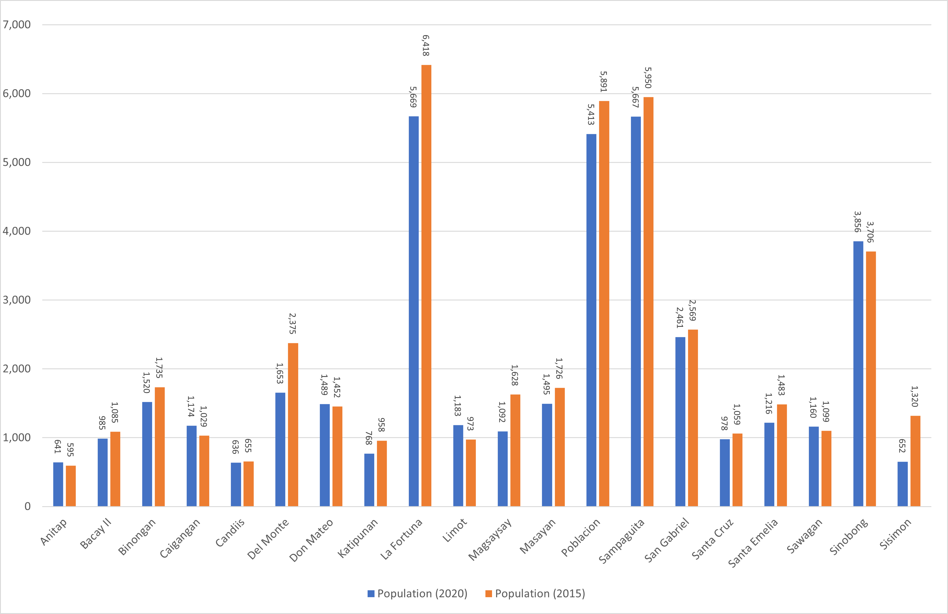
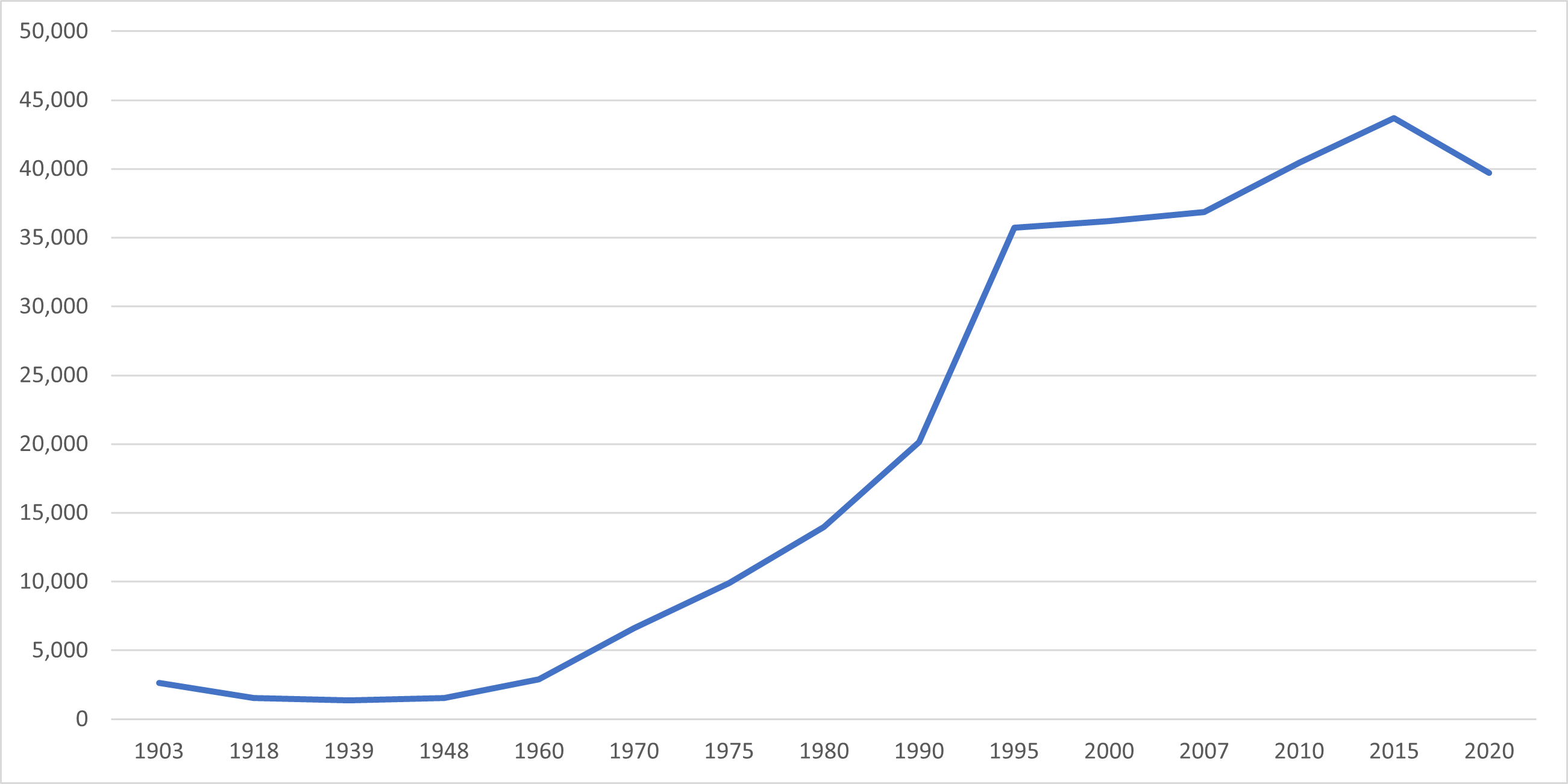
Veruela’s population has increased significantly over the past century, from 2,623 people in 1903 to 39,708 people in 2020, a rise of 37,085 individuals. However, the latest 2020 census shows a negative growth rate of 2.00%, or a decline of 3,998 people, from the previous population of 43,706 in 2015.
Location
Veruela is closest to the cities of Bislig, Surigao del Sur,Tagum, Davao del Norte, Bayugan, Agusan del Sur, Panabo, Davao del Norte, Malaybalay, Bukidnon, and Valencia, Bukidnon, based on the shortest distance between two points on the Earth’s surface, known as the great-circle distance. The nearest municipalities to Veruela include Trento, Santa Josefa, Bunawan, Loreto, La Pazin Agusan delSur, and Monkayo, Davao de Oro. The distance from the national capital is 902.74 kilometers (560.94 miles), and the following list provides more information on the distance measurements.