GOV.PH

Republic of The Philippines

Province of Agusan del Sur

📞 Contact number: 09917351571 
📧 Email Address: santajosefa.ads@gmail.com

Santa Josefa is a third-class municipality in the province in the southernmost settlement in the province.

The land area of the municipality is 341.80 square kilometers or 131.97 square miles, which accounts for 3.42% of the total area of Agusan del Sur. According to the 2020 Census, the population of the municipality is 26,432, representing 3.57% of the total population of Agusan del Sur province and 0.94% of the overall population of the Caraga region. Based on these figures, the population density is calculated to be 77 inhabitants per square kilometer or 200 inhabitants per square mile.


11

Barangay count


8512

Postal code


341.80 km²

Land Area


26,432

Population (2020)


77  / km²

Density

Coordinates


38.3 meters

Estimated elevation above sea level

Barangays

Santa Josefa has 11 barangays. The graph and table below show the population per barangay for the years 2015 and 2020.

BarangayPopulation (2020)Population (2015)
Angas3,5163,271
Aurora2,9692,651
Awao2,1002,232
Concepcion9501,055
Pag-asa8881,122
Patrocinio2,8692,238
Poblacion4,7734,962
San Jose2,3522,486
Santa Isabel1,7372,363
Sayon2,6312,620
Tapaz1,6471,729


Economy

Fiscal YearAnnual Regular Income 
200962,178,594
201067,952,993
201176,282,252
201273,057,398
201380,969,095
201489,854,676
2015101,348,706
2016110,540,919


End notes:

  • Annual Regular Income = Locally Sourced Revenue + Internal Revenue Allotment (IRA) Current Year + Other Shares from National Tax Collection
  • Locally Sourced Revenue = Real Property Tax (General Fund) + Tax on Business + Other Taxes + Regulatory Fees + Service/User Charges + Receipts from Economic Enterprises

Population

Census date Population 
1903
1918393
1939663
1948835
19601,687
19703,601
19754,972
19806,604
199011,392
199521,190
200022,730
200724,972
201025,156
201526,729
202026,432


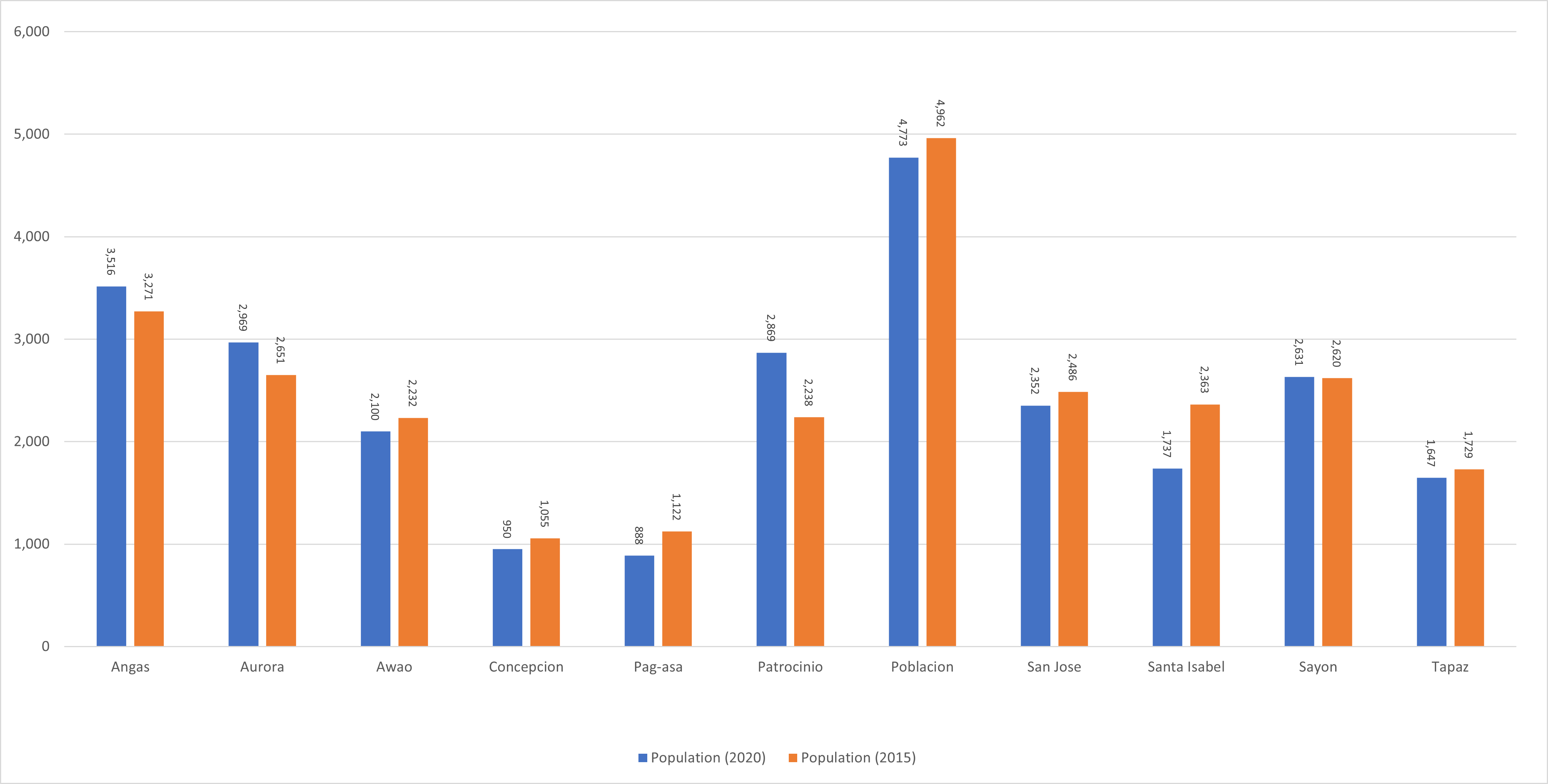
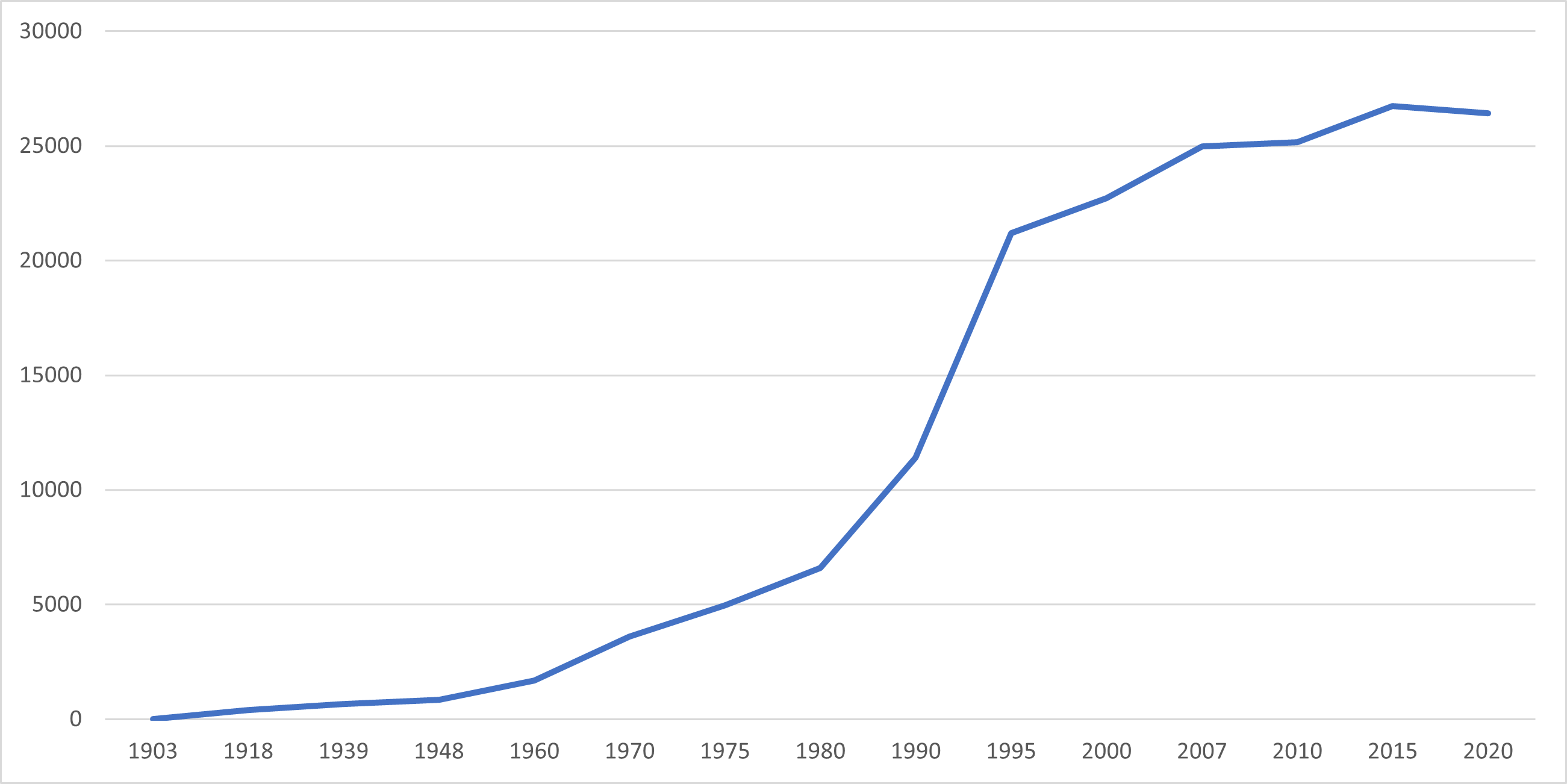
The population of Santa Josefa has significantly increased from 393 in 1918 to 26,432 in 2020, representing a substantial growth of 26,039 people over the past 102 years. However, the latest census figures in 2020 indicate a negative growth rate of 0.23%, indicating a decrease of 297 people compared to the previous population of 26,729 in 2015.

Location

Distances


Santa Josefa is located in the northeastern part of the province of Agusan del Sur in the Philippines. The city of Bislig in Surigao del Sur, Tagum and Panabo in Davao del Norte, and Bayugan, Malaybalay, and Valencia in Bukidnon are the closest cities to Santa Josefa based on great-circle distance. Meanwhile, the nearest municipalities are Trento, Veruela, and Bunawan in Agusan del Sur, Monkayo in Davao de Oro, and Loreto and Montevista in Davao de Oro. The distance between Santa Josefa and the national capital is 915.15 kilometers (568.65 miles).

Great-circle distance


Nearest towns

  • Trento, Agusan del Sur, 7.83 kilometers (4.86 miles) to the North‑Northeast (N28°E)
  • Veruela, Agusan del Sur, 12.43 kilometers (7.72 miles) to the Northwest (N40°W)
  • Monkayo, Davao de Oro, 18.12 kilometers (11.26 miles) to the South (S9°E)
  • Bunawan, Agusan del Sur, 21.84 kilometers (13.57 miles) to the North (N10°W)
  • Loreto, Agusan del Sur, 29.44 kilometers (18.29 miles) to the Northwest (N40°W)
  • Montevista, Davao de Oro, 31.33 kilometers (19.47 miles) to the South (S8°W)

Nearest cities

  • Bislig, Surigao del Sur, 40.65 kilometers (25.26 miles) to the Northeast (N51°E)
  • Tagum, Davao del Norte, 64.06 kilometers (39.81 miles) to the South‑Southwest (S22°W)
  • Panabo, Davao del Norte, 84.61 kilometers (52.57 miles) to the South‑Southwest (S27°W)
  • Bayugan, Agusan del Sur, 86.48 kilometers (53.74 miles) to the North‑Northwest (N21°W)
  • Malaybalay, Bukidnon, 100.71 kilometers (62.58 miles) to the West (N79°W)
  • Valencia, Bukidnon, 103.80 kilometers (64.50 miles) to the West (S85°W)

For more information about the Province of Agusan del Sur