GOV.PH

Republic of The Philippines

Province of Agusan del Sur

San Francisco can serve as an entry point to the Agusan Marsh Wildlife Sanctuary through the Barangays Caimpugan and New Visayas.

The town is famous for the massive Toog Tree of Alegria, which holds significant spiritual value for the indigenous people of San Francisco. Additionally, the town is renowned for its Irosin stone crafts, which have been a traditional cottage industry for many indigenous families in the area for centuries.

The municipality covers a land area of 392.53 square kilometers (or 151.56 square miles), accounting for 3.93% of Agusan del Sur’s total area. The 2020 Census reported a population of 80,760 in the municipality, which represents 10.92% of the total population of Agusan del Sur province, or 2.88% of the overall population of the Caraga region. Based on these figures, the population density can be computed at 206 inhabitants per square kilometer (or 533 inhabitants per square mile).


27

Barangay count


8501

Postal code


392.53 km²

Land Area


80,760

Population (2020)


206 / km²

Density

Coordinates


33.7 meters

Estimated elevation above sea level

Barangays

San Francisco has 27 barangays. The graph and table below show the population per barangay for the years 2015 and 2020.

BarangayPopulation (2020)Population (2015)
Alegria           8,007           7,310
Barangay 1           5,579           5,902
Barangay 2           2,492           2,506
Barangay 3           3,569           3,642
Barangay 4           3,392           2,939
Barangay 5           6,058           5,239
Bayugan 2           5,708           4,644
Bitan-agan           1,099           1,046
Borbon           2,835           2,850
Buenasuerte           1,300           1,566
Caimpugan           1,889           1,590
Das-agan           1,720           1,824
Ebro           1,201           1,325
Hubang           3,720           3,166
Karaus           3,717           3,148
Ladgadan           1,050               981
Lapinigan           5,324           5,150
Lucac           1,661           1,294
Mate           1,422           1,497
New Visayas           1,962           1,334
Ormaca               893               805
Pasta           3,160           3,061
Pisa-an           3,647           3,429
Rizal               756               904
San Isidro           4,422           3,737
Santa Ana           1,577           1,256
Tagapua           2,600           2,397

Economy

Fiscal YearAnnual Regular Income 
2009123,958,394
2010132,048,866
2011146,925,843
2012151,488,711
2013173,351,749
2014204,628,240
2015225,546,110
2016248,724,166


End notes:

  • Annual Regular Income = Locally Sourced Revenue + Internal Revenue Allotment (IRA) Current Year + Other Shares from National Tax Collection
  • Locally Sourced Revenue = Real Property Tax (General Fund) + Tax on Business + Other Taxes + Regulatory Fees + Service/User Charges + Receipts from Economic Enterprises

Population

Census date Population 
1903
1918
1939
19485,434
196016,535
197017,636
197519,097
198027,153
199043,878
199550,844
200056,968
200762,881
201070,986
201574,542
202080,760


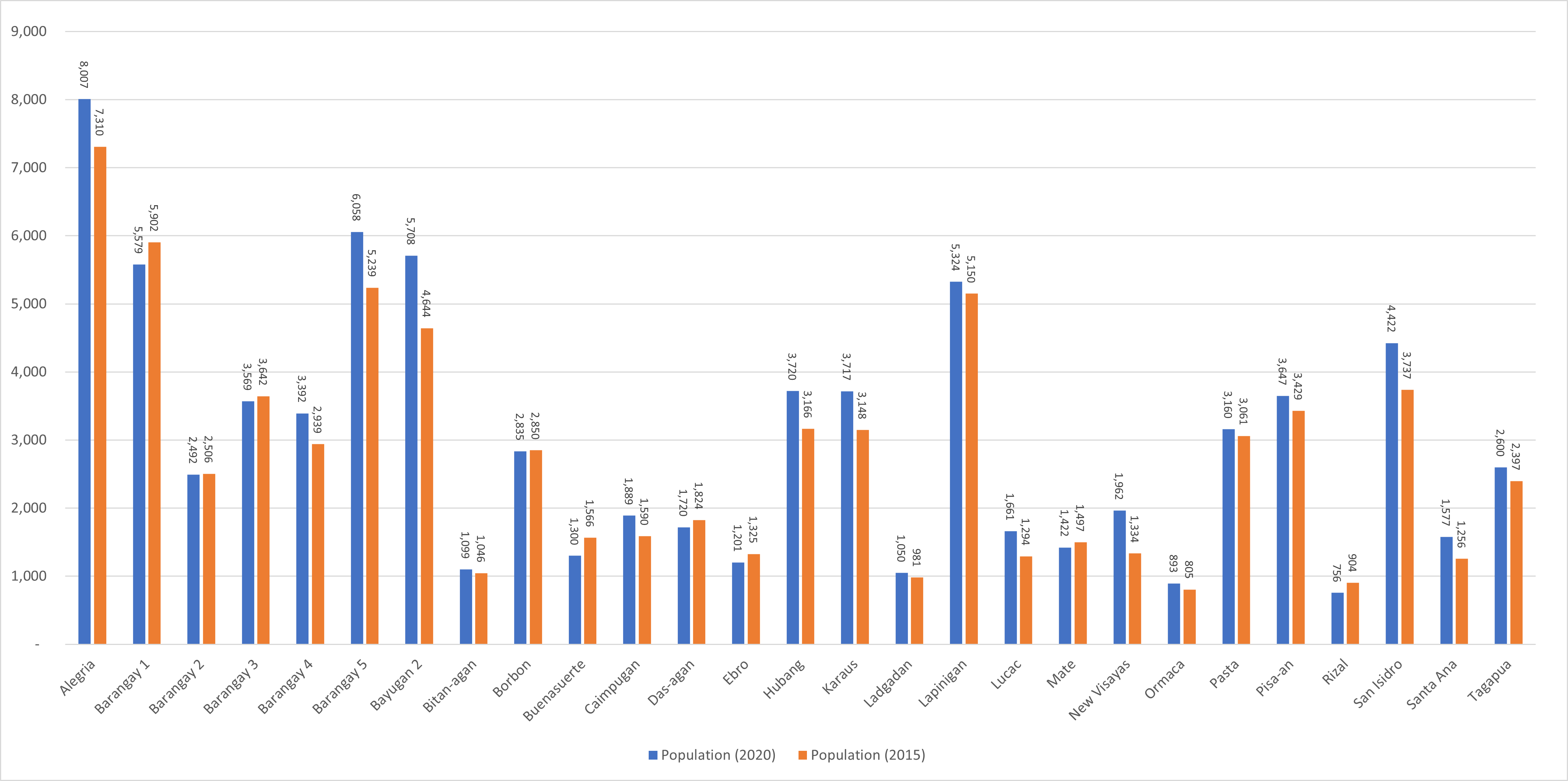
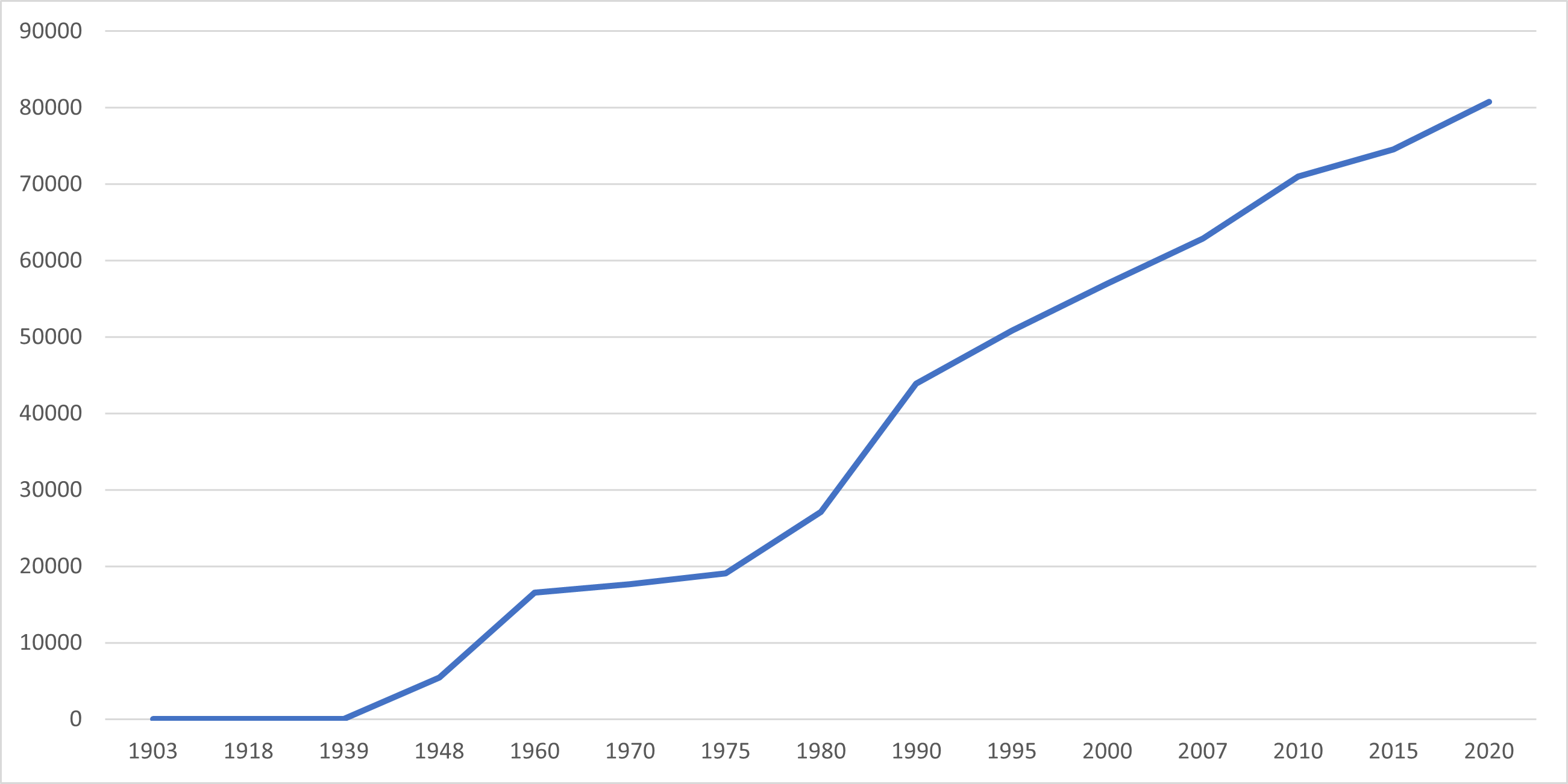
San Francisco’s population has undergone significant growth over the past 81 years, increasing from 4,156 individuals in 1939 to 80,760 people in 2020. This represents a total population growth of 76,604 individuals over the course of 81 years. According to the latest census figures in 2020, San Francisco’s population continues to grow at a positive rate of 1.70%, with an increase of 6,218 people from the previous population of 74,542 in 2015.

Location

Distances


Based on the great-circle distance, the cities that are closest to San Francisco are Bayugan, Agusan del Sur, Bislig, Surigao del Sur, Tandag, Surigao del Sur, Butuan and Cabadbaran, Agusan del Norte, and Malaybalay, Bukidnon. The nearest municipalities are Prosperidad and Rosario, Agusan del Sur, Barobo and Lianga, Tagbina , Surigao del Sur, and Talacogon, Agusan del Sur. The distance from San Francisco to the national capital is 866.02 kilometers (or 538.12 miles). Here’s a list of the distance measurements to the aforementioned cities and municipalities from San Francisco based on great-circle distance:

Great-circle distance


Nearest towns

  • Prosperidad, Agusan del Sur, 13.05 kilometers (8.11 miles) to the North‑Northwest (N31°W)
  • Rosario, Agusan del Sur, 13.93 kilometers (8.66 miles) to the South (S11°E)
  • Barobo, Surigao del Sur, 16.19 kilometers (10.06 miles) to the East‑Northeast (N78°E)
  • Lianga, Surigao del Sur, 19.05 kilometers (11.84 miles) to the Northeast (N42°E)
  • Tagbina, Surigao del Sur, 20.56 kilometers (12.77 miles) to the East‑Southeast (S75°E)
  • Talacogon, Agusan del Sur, 21.85 kilometers (13.57 miles) to the West‑Southwest (S73°W)

Nearest cities

  • Bayugan, Agusan del Sur, 34.22 kilometers (21.27 miles) to the Northwest (N47°W)
  • Bislig, Surigao del Sur, 49.39 kilometers (30.69 miles) to the Southeast (S49°E)
  • Tandag, Surigao del Sur, 68.04 kilometers (42.28 miles) to the North‑Northeast (N21°E)
  • Butuan, 69.95 kilometers (43.46 miles) to the Northwest (N45°W)
  • Cabadbaran, Agusan del Norte, 83.90 kilometers (52.13 miles) to the Northwest (N35°W
  • Malaybalay, Bukidnon, 100.97 kilometers (62.74 miles) to the West‑Southwest (S67°W)

For more information about the Province of Agusan del Sur