GOV.PH

Republic of The Philippines

Province of Agusan del Sur

Previously, Rosario was a part of San Francisco until it became a separate municipality on June 21, 1969, through the enactment of Republic Act No. 5760. The town was named after its patron saint, Nuestra Senora del Rosario.

With a land area of 385.05 square kilometers or 148.67 square miles, the municipality makes up 3.85% of the total area of Agusan del Sur. According to the 2020 Census, its population was 49,610, accounting for 6.71% of Agusan del Sur’s total population and 1.77% of the Caraga region’s overall population. Based on these statistics, the population density can be calculated as 129 inhabitants per square kilometer or 334 inhabitants per square mile.


11

Barangay count


8504

Postal code


385.05 km²

Land Area


30,969

Population (2020)


129 / km²

Density

Coordinates


31.3 meters

Estimated elevation above sea level

Barangays

Esperanza has 15 barangays. The graph and table below show the population per barangay for the years 2015 and 2020.

BarangayPopulation (2020)Population (2015)
Bayugan 314,84813,922
Cabantao1,8921,723
Cabawan1,5701,357
Libuac3,2083,085
Maligaya1,5171,706
Marfil1,9141,914
Novele2,6532,695
Poblacion5,4315,131
Santa Cruz9,4798,659
Tagbayagan2,4472,100
Wasi-an4,6514,391


Economy

Fiscal YearAnnual Regular Income 
200980,172,081
201085,681,406
201199,964,105
2012106,253,683
2013117,358,056
2014120,621,225
2015140,830,457
2016162,118,566


End notes:

  • Annual Regular Income = Locally Sourced Revenue + Internal Revenue Allotment (IRA) Current Year + Other Shares from National Tax Collection
  • Locally Sourced Revenue = Real Property Tax (General Fund) + Tax on Business + Other Taxes + Regulatory Fees + Service/User Charges + Receipts from Economic Enterprises

Population

Census date Population 
1903
1918291
19390
1948
1960
19707,885
19759,774
198012,443
199025,436
199526,836
200028,675
200731,293
201038,280
201546,683
202049,610


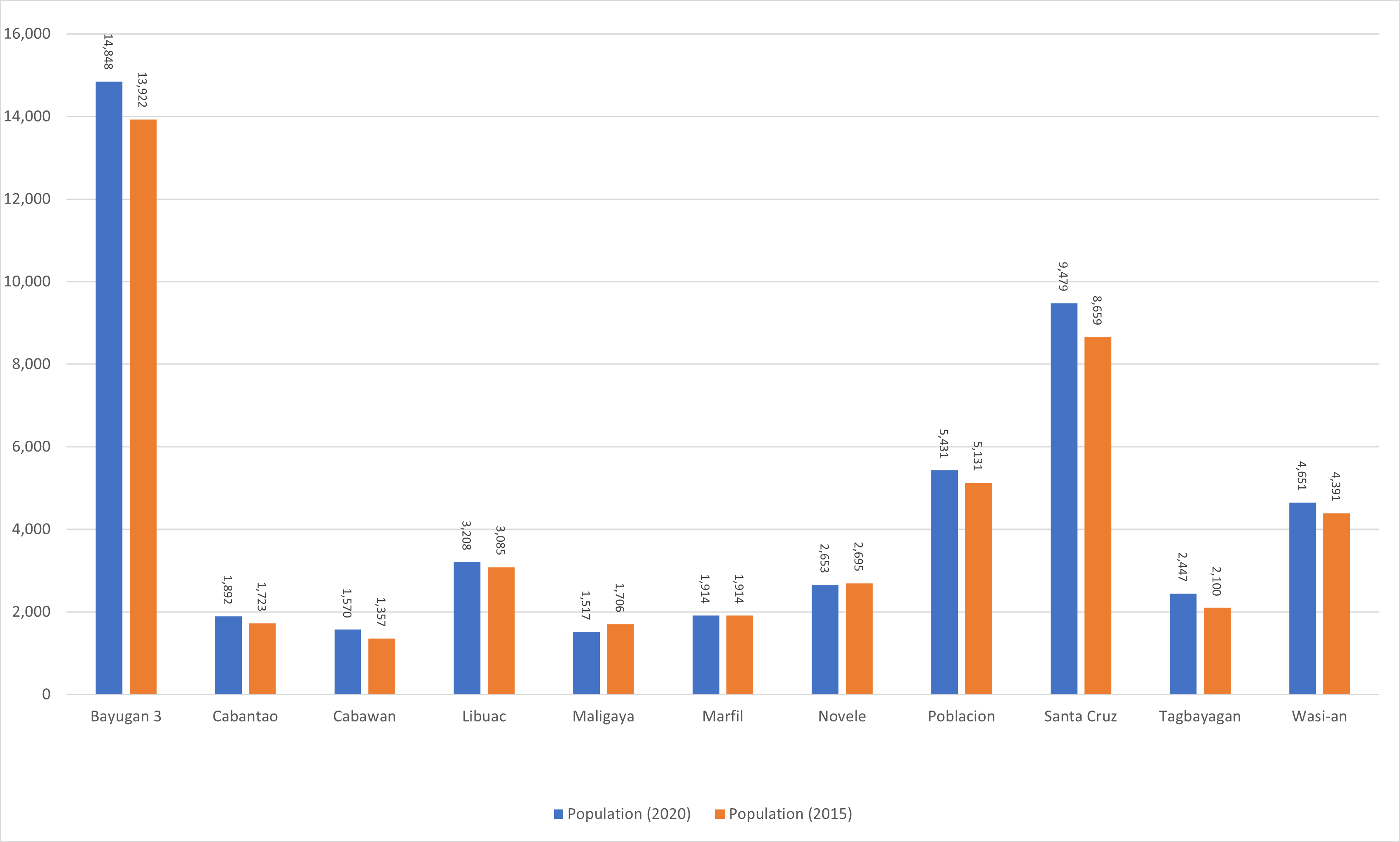
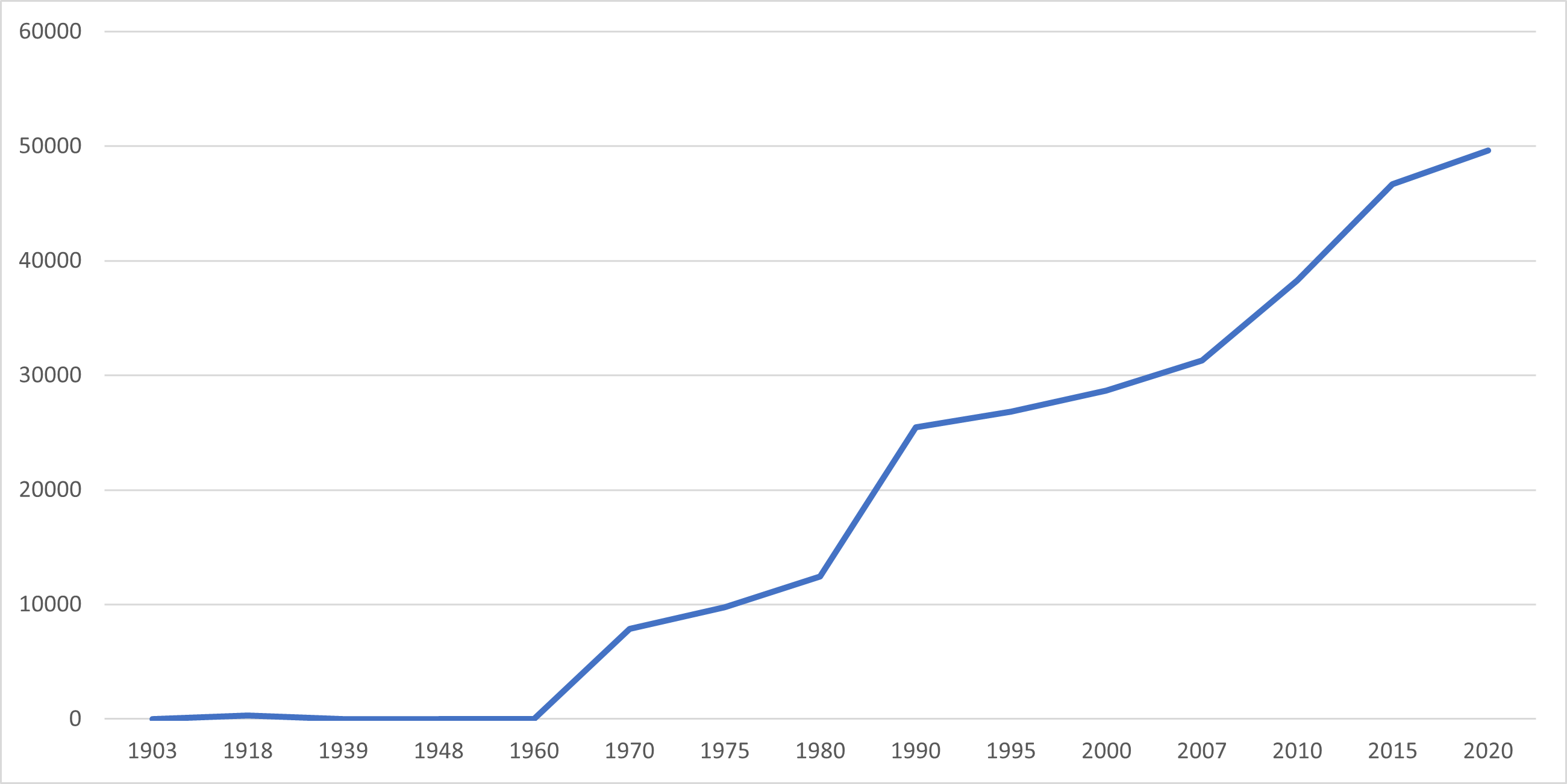
Rosario’s population has experienced significant growth over the last century, increasing from 291 individuals in 1918 to 49,610 people in 2020. This represents a total population growth of 49,319 people over a period of 102 years. According to the latest census figures in 2020, Rosario’s population continues to grow at a positive rate of 1.29%, with an increase of 2,927 people from the previous population of 46,683 in 2015.

Location

Distances


Based on the great-circle distance (the shortest distance between two points over the surface of the Earth), the cities closest to Rosario are Bislig, Surigao del Sur, Bayugan, Agusan del Sur, Tandag, Surigao del Sur, Butuan, Cabadbaran, Agusan del Norte, and Malaybalay, Bukidnon. The nearest municipalities are San Francisco, Agusan del Sur, Tagbina, Surigao del Sur, Barobo, Surigao del Sur, Bunawan, Agusan del Sur, La Paz, Agusan del Sur, and Talacogon, Agusan del Sur. Its distance from the national capital is 878.41 kilometers (545.82 miles). The following list delineates such distance measurements.

Great-circle distance


Nearest towns

  • San Francisco, Agusan del Sur, 13.93 kilometers (8.66 miles) to the North (N11°W)
  • Tagbina, Surigao del Sur, 19.17 kilometers (11.91 miles) to the East‑Northeast (N64°E)
  • Barobo, Surigao del Sur, 21.43 kilometers (13.32 miles) to the Northeast (N38°E)
  • Bunawan, Agusan del Sur, 22.50 kilometers (13.98 miles) to the South (S2°W)
  • La Paz, Agusan del Sur, 23.96 kilometers (14.89 miles) to the West‑Southwest (S62°W)
  • Talacogon, Agusan del Sur, 24.78 kilometers (15.40 miles) to the West‑Northwest (N72°W)

Nearest cities

  • Bislig, Surigao del Sur, 39.36 kilometers (24.46 miles) to the East‑Southeast (S62°E)
  • Bayugan, Agusan del Sur, 46.19 kilometers (28.70 miles) to the Northwest (N37°W)
  • Tandag, Surigao del Sur, 80.20 kilometers (49.83 miles) to the North‑Northeast (N15°E)
  • Butuan, 81.91 kilometers (50.89 miles) to the Northwest (N39°W)
  • Cabadbaran, Agusan del Norte, 96.76 kilometers (60.13 miles) to the North‑Northwest (N32°W)
  • Malaybalay, Bukidnon, 99.17 kilometers (61.62 miles) to the West‑Southwest (S75°W)

For more information about the Province of Agusan del Sur