GOV.PH

Republic of The Philippines

Province of Agusan del Sur

The arrival of the Spaniards in the upper reaches of Agusan and the discovery of the Manobos occurred in 1600, long before Fr. Urios came to the region in the 1880s. The Manobos were persuaded to form a settlement and live in a community named “Loreto” on March 30, 1965, in honor of Fr. Urios’s hometown in Spain.

The municipality’s land area spans 1,462.74 square kilometers (or 564.77 square miles), making up 14.64% of the total area of Agusan del Sur. According to the 2020 Census, the municipality’s population was 43,880, representing 5.93% of the total population of Agusan del Sur province, or 1.56% of the entire population of the Caraga region. Based on these statistics, the population density can be calculated at 30 inhabitants per square kilometer (or 78 inhabitants per square mile).


17

Barangay count


8507

Postal code


1,467.74 km

Land Area


43,880

Population (2020)


30 / km2

Density


8.1856125.8538

Coordinates


26.3 meters

Estimated elevation above sea level

Barangays

Esperanza has 15 barangays. The graph and table below show the population per barangay for the years 2015 and 2020.

BarangayPopulation (2020)Population (2015)
Binucayan3,1382,781
Johnson1,6911,433
Kasapa1,9751,738
Katipunan633525
Kauswagan2,1532,445
Magaud3,5523,314
Nueva Gracia2,5612,270
Poblacion7,1076,384
Sabud2,6744,367
San Isidro1,6341,601
San Mariano2,5012,411
San Vicente2,3352,163
Santa Teresa2,2442,325
Santo Niño1,3211,088
Santo Tomas4,3633,859
Violanta1,5721,439
Waloe2,4262,358


Economy

Fiscal YearAnnual Regular Income 
2009142,511,876
2010150,790,078
2011163,603,280
2012158,605,065
2013180,217,787
2014203,358,396
2015232,667,189
2016256,405,187


End notes:

  • Annual Regular Income = Locally Sourced Revenue + Internal Revenue Allotment (IRA) Current Year + Other Shares from National Tax Collection
  • Locally Sourced Revenue = Real Property Tax (General Fund) + Tax on Business + Other Taxes + Regulatory Fees + Service/User Charges + Receipts from Economic Enterprises

Population

Census date Population 
1903 – 
1918              908
1939          2,418
1948          2,701
1960          5,746
1970          7,971
1975        12,634
1980        14,389
1990        16,144
1995        23,044
2000        20,880
2007        25,214
2010        28,562
2015        28,217
2020        30,969


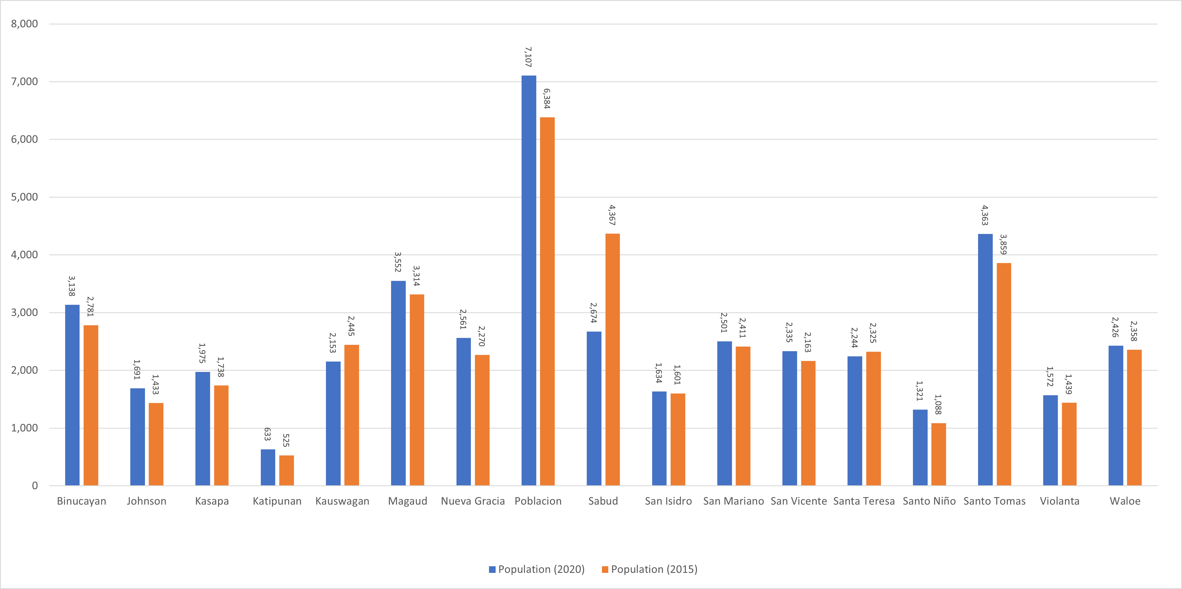
Over the past century, Loreto’s population has undergone significant growth, rising from 2,447 individuals in 1918 to 43,880 people in 2020. This represents a total population increase of 41,433 individuals over the course of 102 years. According to the most recent census figures in 2020, Loreto’s population continues to grow at a positive rate of 0.67%, with an increase of 1,379 people from the previous population of 42,501 in 2015.

Location

Distances


Based on the great-circle distance (the shortest distance between two points over the surface of the Earth), the cities closest to Loreto are Bislig, Surigao del Sur, Bayugan, Agusan del Sur, Malaybalay, Bukidnon, Tagum, Davao del Norte, Valencia, Bukidnon, and Butuan. The nearest municipalities are La Paz, Agusan del Sur, Bunawan, Agusan del Sur, Veruela, Agusan del Sur, Rosario, Agusan del Sur, Trento, Agusan del Sur, and Santa Josefa, Agusan del Sur. Its distance from the national capital is 885.79 kilometers (550.40 miles). The following list delineates such distance measurements.

Great-circle distance


Nearest towns

Nearest cities

  • Bislig, Surigao del Sur, 51.03 kilometers (31.71 miles) to the East (N87°E)
  • Bayugan, Agusan del Sur, 59.62 kilometers (37.05 miles) to the North (N11°W)
  • Malaybalay, Bukidnon, 79.79 kilometers (49.58 miles) to the West (S88°W)
  • Tagum, Davao del Norte, 81.85 kilometers (50.86 miles) to the South (S3°W)
  • Valencia, Bukidnon, 89.84 kilometers (55.82 miles) to the West‑Southwest (S70°W)
  • Butuan, 92.15 kilometers (57.26 miles) to the North‑Northwest (N23°W)

For more information about the Province of Agusan del Sur